
The Week Ahead…
We’ll have to deal with a few nuisance weather impacts over the next few days, but unfortunately, as of this morning, I am not seeing any significant snow in the next week or so. Next weekend is still a little muddled and could end up snowy, but trends have pushed the snow away–more on that below.
We’ll see some snow showers today (Sunday) that might sometimes mix with freezing drizzle. Beyond today, we have a few cold fronts sliding through that will slightly bring temperatures down with each passage. Some light snow is possible with each front, but no significant accumulation is expected. The wild card could be lake-effect snow, but based on current data, I think the lake-effect snow stays north of the IN/MI state line.
The Next Winter Storm?
There were signs of yet another potential winter storm impacting the Midwest and Great Lakes late next week. Late last week, the trend was moving the storm track further south until today, when the storm is all but gone in one model and moves through Kentucky, Tennessee, and West Virginia in the other. Confidence in this potential system has gone from low to essentially non-existent.
We’re talking about something over a week away, so there is plenty of time for fluctuation. The CPC Hazards outlook page featured a slight risk for heavy snow in the Midwest and Great Lakes for three days straight up until this weekend (this outlook only updates on weekdays around 3 PM Eastern). There was a subtle but noticeable trend south with this outlook as well. However, the outlook still safely included our region on Friday.
I’m not entirely giving up on this just yet, but I may around 3 PM tomorrow if the latest hazards outlook matches up with the trends in the GFS and Euro models from this weekend.
Bitter Cold On The Way!
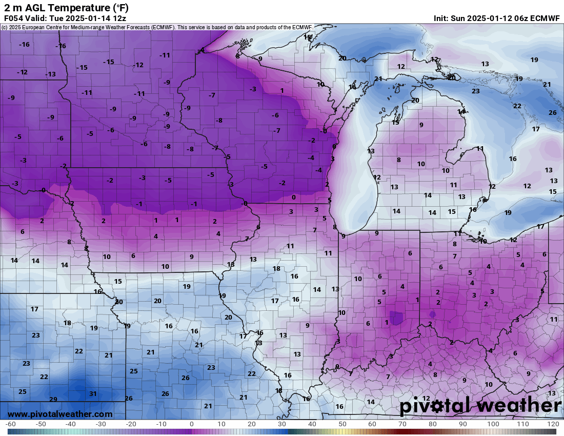
We’ve seen our fair share of cold weather already this winter, but the (relatively) warm waters of Lake Michigan and the clouds it has produced have acted like a blanket to help prevent Goshen’s temperatures from tanking. Last week, central Indiana saw low temperatures in the single digits on either side of zero thanks to the fresh blanket of snow they got a week ago and a shot of arctic air. We saw the same cold air mass, but with just enough northwest wind coming off the lake, we were 10-15 degrees warmer last week.
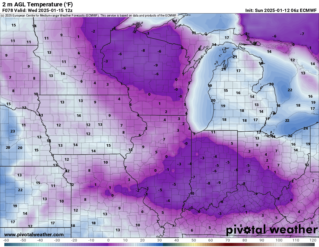
A cold front will slide through late today and tomorrow, and the high temperatures we have seen in the upper 20s will become a thing of the past. By tomorrow, we’ll be lucky to crack 20 degrees. Another cold front will slide through early next week and may be enough for us to see some single-digit low temperatures. Anytime we get into the single digits, even a slight breeze will bring wind chills at or below zero. Below-zero wind chills will be something to watch on Tuesday and Wednesday mornings. Thursday morning should be cold, too. It doesn’t appear that we will be cold enough to see disruptions to local schools.

The chill expected midweek will wane by next weekend, but this will depend mainly on the track of the aforementioned potential winter storm next weekend. We may be warm enough that whatever we see falls as a mixture of rain and snow. I don’t want to speculate too much on this, given the trend in model runs this weekend and the fact that it is so far away. Again, a lot is riding on that Hazard Outlook at 3 PM tomorrow.
Polar Vortex
“Polar Vortex” is a buzzword that the weather weenies love to throw around when it gets cold. The polar vortex is real, but in a nutshell, it is nothing more than the lobe of extremely cold, polar air that generally stays trapped well to our north in Canada–even in the winter. However, on occasion, atmospheric drivers line up just right such that a “polar coaster” forms, allowing a massive chunk of cold air to slide from far northwest Canada southeast into the United States east of the Rocky Mountains. And sometimes, that cold air makes it all the way to the southern Great Lakes. It looks like this may happen just beyond next weekend.
If you’ve been with me a while, you know I don’t like any forecast beyond 3 days. Any precipitation forecast beyond 3 days cannot be trusted, in my opinion, unless you’re in Florida and a hurricane is coming. However, temperatures are another story, especially when discussing air masses. The continental polar air mass is dry, and cold air is generally associated with the polar vortex. There are reasonable indications that this air mass will slide south and impact our region around the week of January 20th. Highs in the single digits are possible, with lows at or below zero. And that’s without the windchills. The other issue with this potential cold is that it might last several days. The GFS and Euro models support it. Also, yesterday’s CPC temperature outlook was striking and supported a cold outbreak.
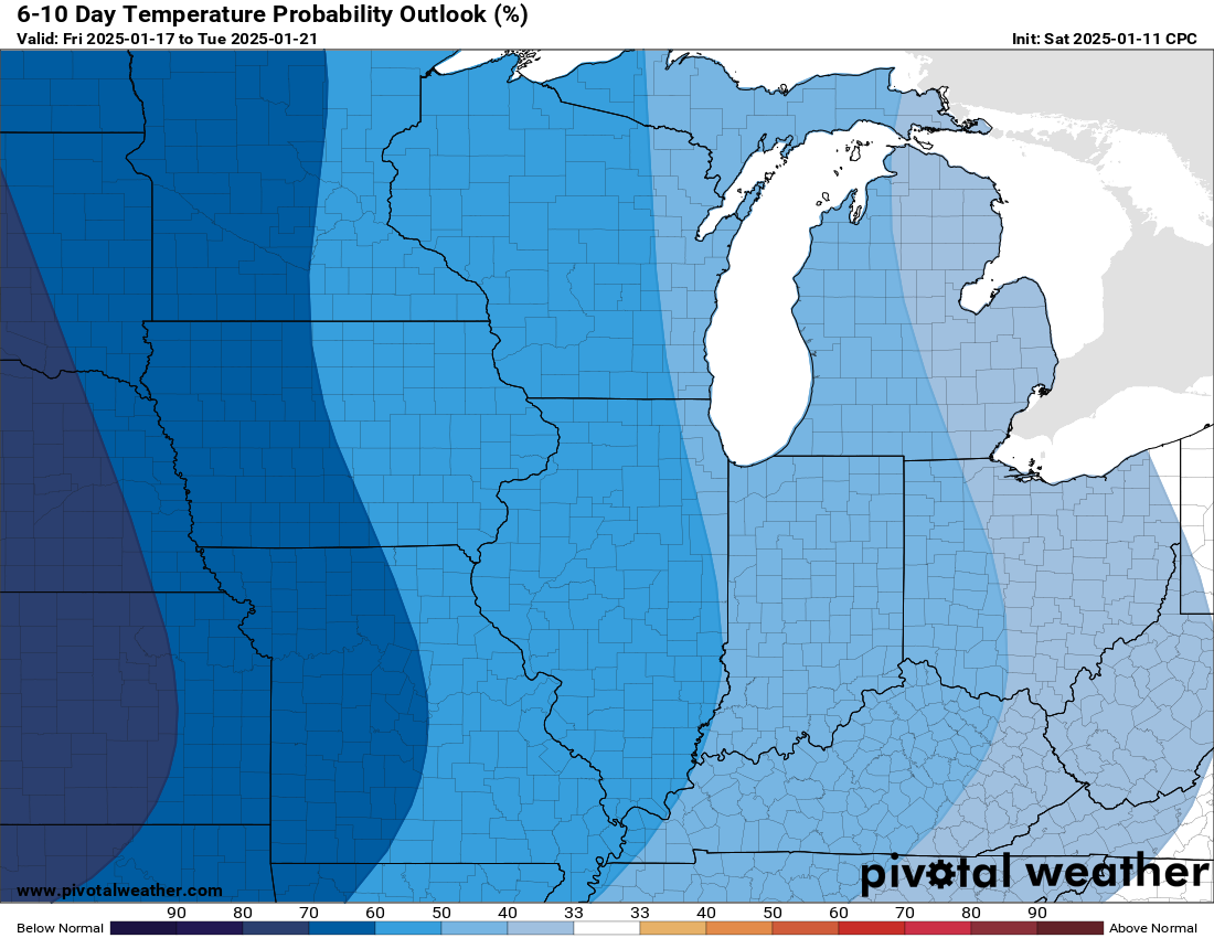
We are officially in the climatological coldest part of the year in Goshen. Based on data going back as far as 1914, our normal high this time of year is around 32 degrees, with a low of around 18 degrees. Check out the CPC outlooks for 6-10 days and 8-14 days from now. Should these be verified, we would be looking at temperatures as much as 20 to even 30 degrees below normal.
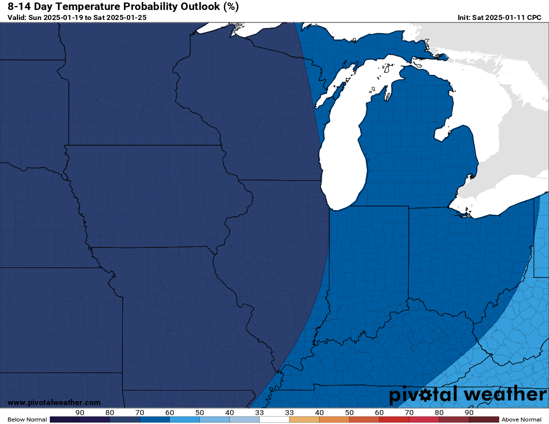
I was recently asked what “hazardous” meant. If this pans out, these temperatures would be hazardous. Again, equally concerning is the potential longevity of the cold. It looks like it could last several days. I mentioned a few days ago that (finally) the CPC outlook calling for cold matched up with above-normal precipitation, and this is still true in the latest run of the 6-10-day range. It certainly appears that winter is getting revved up and could be peaking during the week of January 20th that we’ve been highlighting for a while now. I’ll keep you updated, thanks for reading.
-pw

Leave a comment