Let’s start with the next few days, and then we’ll get to the brutally cold air on the way. Anything that melts today and remains untreated will freeze overnight, so be careful in the morning. The good news is that it looks like we will see some sunshine tomorrow! Even better, we should “soar” into the mid- to upper 30s! I’m not quite ready to issue a Severe Clear Watch, but it should be a decent day tomorrow—though it will be a little breezy.
Snow returns late Friday and continues into the first part of Saturday. This will be wetter, heavier snow than we have been seeing, but it will still be less than an inch. With a high near freezing, some drizzle or even freezing drizzle could mix in. From this point on, things get a little more interesting.
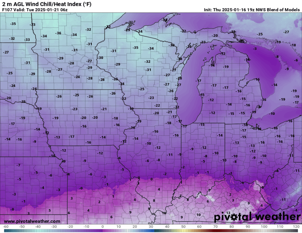
A cold front is expected to pass Saturday afternoon or so and could result in a flash freeze Saturday evening. Temps crash from the low to mid-30s early Saturday into the teens by Saturday night. Temps remain in the teens most of Sunday before another reinforcing shot of cold air drops the mercury below zero Sunday night into Monday morning. Lows will likely land between 0 and -5°F. Wind chills will drop to -20°F or lower.
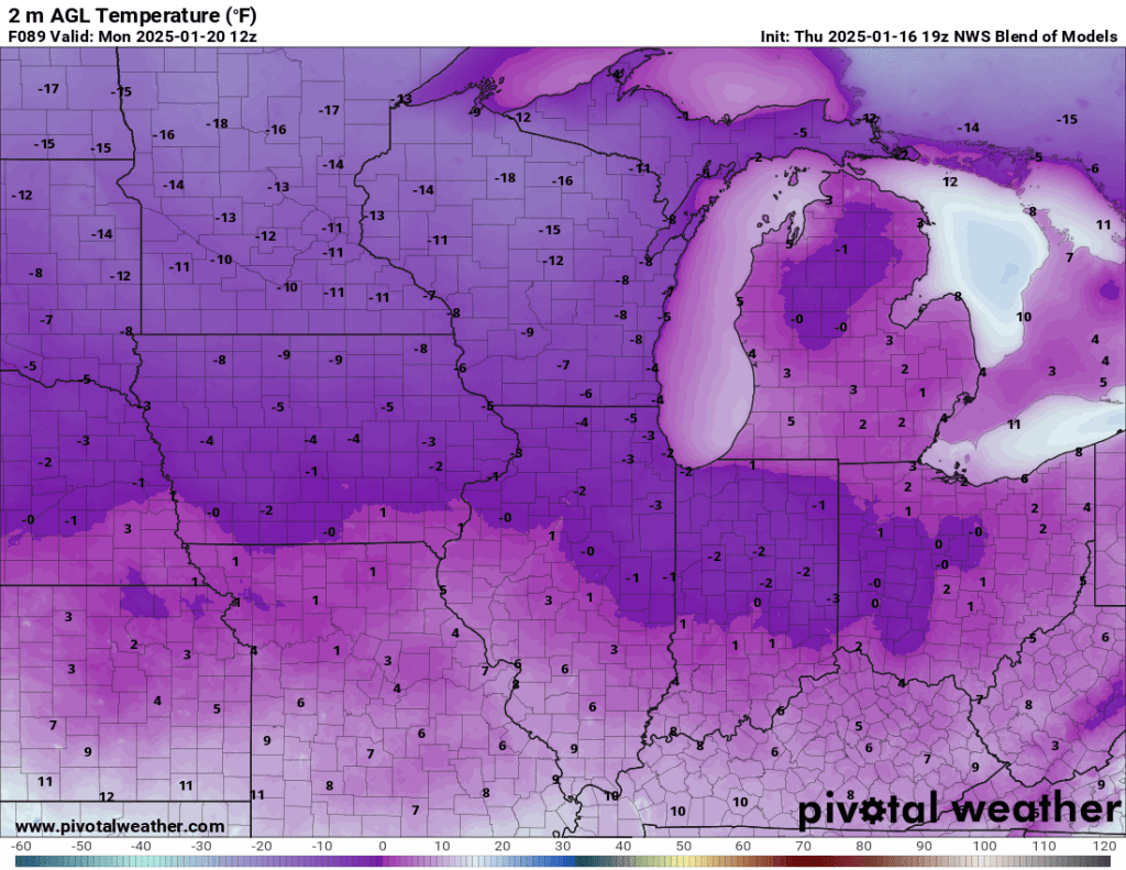
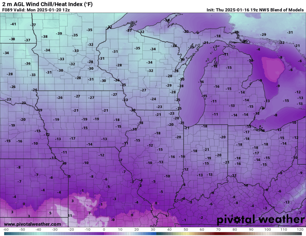
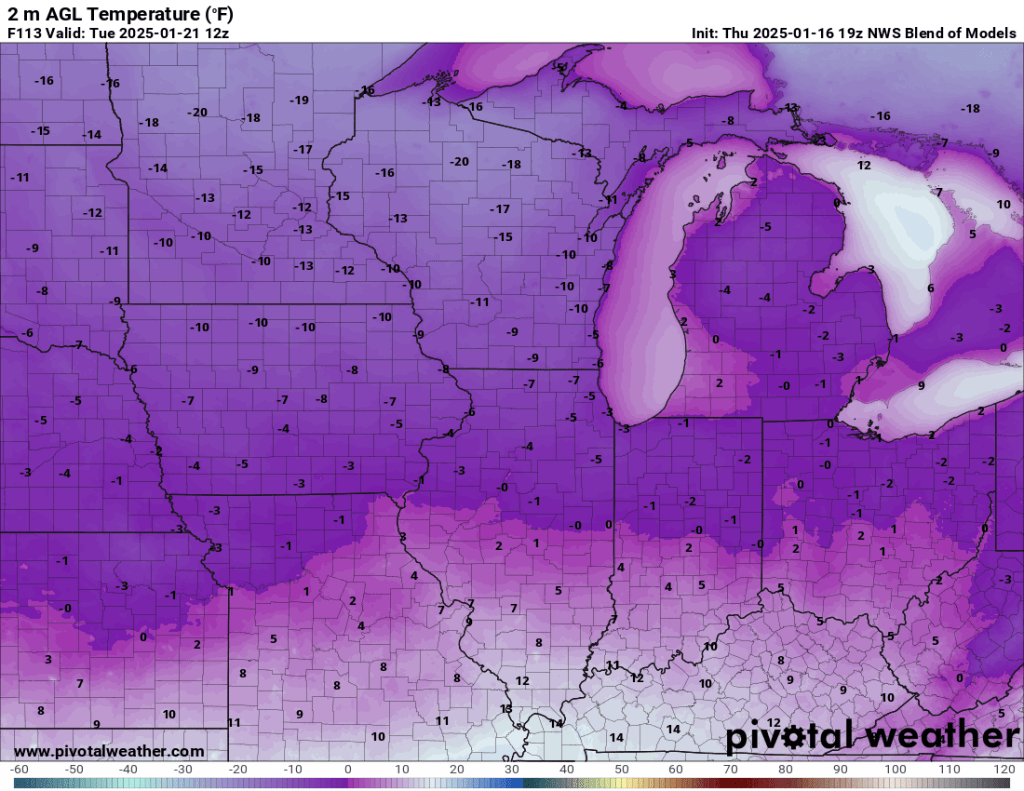
There is little moderation in temperature expected on Monday, with a high temperature likely to peak at or below 5°F. Windchills will remain at or below -20°F straight through Wednesday morning. Lows Monday night into Tuesday morning are expected to fall to between -5°F and -10°F. Tuesday’s “high” is also expected to be 5°F or lower. Tuesday night into Wednesday morning, we drop to around -5°F again.

If you’ve been following this site, none of this should be a surprise. At this point, it has been well-advertised for nearly two weeks. The only thing that’s missing is the snow.
With the bitterly cold air coming across the still open waters of Lake Michigan, the lake-effect snow machine will kick on. The problem is also why our temperatures are going to be so low. The wind is expected to come mainly out of the west. This will keep the lake-effect snow and associated clouds that have previously acted like a blanket to limit radiation cooling will stay just to our north and allow our temperatures to plummet.
The Euro model is very bullish on snow in western and southwestern Michigan. If it is to be believed, parts of that area could see over two feet of snow by next week. The Euro also throws 3-6” our way as the winds wobble and sometimes send some snow our way.
3-6” over a week doesn’t sound like a big deal, but as we saw earlier this week, an inch of snow + gusty winds + temps in the teens = reduced visibility and difficult travel. The general idea, though, is that the bulk of the lake effect snow stays well to our north, and I would (pleasantly) be surprised to see us get more than an inch or two.
So far this winter, we have received roughly 16” of snow, which is about 8” behind schedule.
You may also hear about a potential winter storm for part of the Deep South. This has everything to do with our cold air. The extremely cold air mass associated with the North Pole is being caught up in the atmospheric river known as the jet stream. A large bubble called a block over Alaska right now is acting a little like a giant boulder in that atmospheric river. And just like in a big river, the water has to move around those boulders. But in this case, the river is extremely cold air that is generally allowed to travel “boulder” free across Alaska, into northern Canada, then across the Arctic circle into Siberia before returning to Alaska.
To put this cold air into perspective, parts of Siberia recently saw temperatures fall to -65°F. That’s the same air mass currently worming around Alaska before veering southeast into Canada and eventually the central and southeastern United States. We won’t see anything like -65°F, but it is the same air mass.
This ridge and blocking pattern is also part of the cause of the winds leading to the spread of the devastating wildfires in Southern California.
Outside of the lake-effect snow, not much precipitation is expected. Not only is the cold air extremely dry, it is also much denser relative to warmer air which will result in very high pressure and gusty winds.
Despite all the hype about the cold coming, it is unlikely that we will set any record minimum low temperatures. The record minimum high temperature on Monday is -8°F (1985). Our current forecast is a high of roughly 5°F. The minimum low is -23°F (1943), and our current forecasted low is about -5°F. In case you’re wondering, the normal high is 31°F, and the low is 17°F.
The record minimum high temperature on Tuesday is 0° (1984). We may have a shot at breaking that record. The minimum low is -24°F (1984).
That’s almost it. The last thing I have to say is: “buckle up.” It does not appear that the subzero temperatures next week will be the last of the year—they may not even be the last of January. We are on the doorstep of what could be a memorable stretch of wintry weather, the likes of which we haven’t seen in about a decade. And even though we are sitting roughly 8” below normal in the snowfall department, I still feel very confident that we will end the season near normal and around the 47” season total I called for last month.
As always, thanks for reading, and stay warm, friends.
-pw

Leave a comment