Wednesday PM Update
I mentioned in this morning’s update that I felt most confident in widespread snow totals on the lower end of the 3-6” range, which seems more likely now than ever. We aren’t done with the snow, but dry air has eaten away at it and allowed for some freezing drizzle to mix in. Both of these things will keep totals in check. I don’t expect widespread issues tomorrow morning, but it will be colder than it has been recently and slick regardless of how much snow we end up with.
Wednesday AM Update
There are no significant changes to thinking for today and tonight’s wintry weather. Models have trended a tick lower with amounts and maybe a hair faster with this system, both of which have taken ever so slightly away from the overall impact of this system.
A wintry mix will become all snow and leave less than 0.05” of ice and 3-6” of snow.
I feel more confident in widespread snow totals on the lower end of that range, with a few pockets seeing amounts closer to the higher end. With the smaller window and lower amounts, impacts to travel tonight will be present but should be somewhat limited by tomorrow morning. Keep an eye out for school delays, nonetheless.
Tuesday PM Update
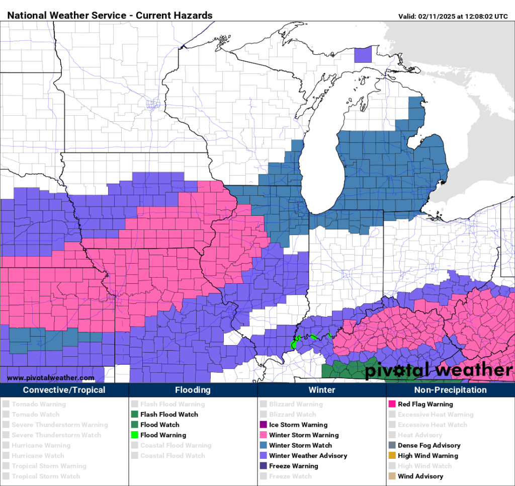
Very little change in model data today other than an overall trend down in snow totals that prompted the NWS to go with an area wide Winter Weather Advisory in lieu of a Winter Storm Warning. 3-6” of wet snow is what I said this morning and I don’t see any reason to change that. And don’t be surprised if things start off as a wintry mix. We should quickly change to all snow Wednesday afternoon and evening. The weekend system still looks interesting.
Tuesday AM Update in bold below. All images have been updated as of 7 AM Tuesday.
For the last three days, the global models have been bullish on moderate to heavy snow sometime between Wednesday and Friday in our vicinity. The big dogs (Euro and GFS) are still seeing moderate to heavy snow, but the Euro has shifted the heaviest snow just northward into Chicagoland. The model runs overnight and shifts things back to the east. If this continues today, it would add confidence to more snow locally. This shift is evident in every model, which is rare and lends itself to higher confidence.

The GFS is the outlier, keeping moderate to heavy snow in Michiana. It remains the eastern outlier. The GFS also has higher snow totals than most other models.

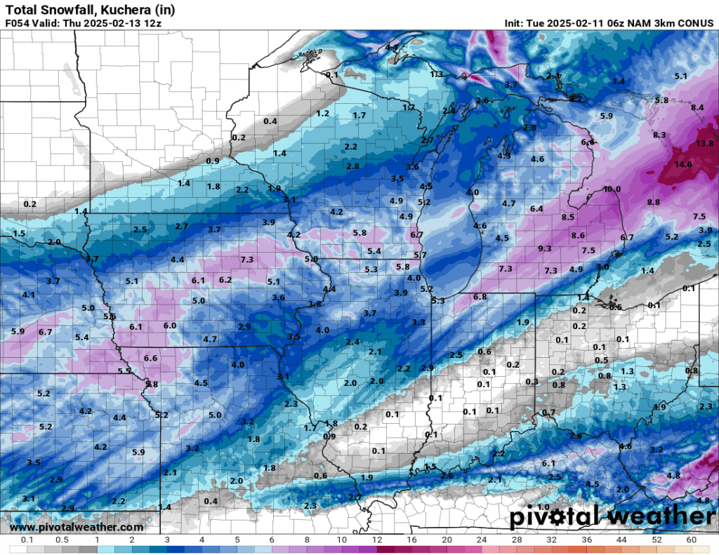
The CAMs mostly follow the Euro, with the NAM 3km being the lone outlier, which trended with the GFS. Again, both NAM models below showed a subtle shift back east. This slight shift is often insignificant; however, the rain/snow line is still expected to create a tight gradient. On one side, you’ll have mostly snow; on the other, you’ll see more rain and ice mixing in with the snow.
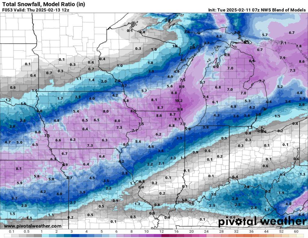
At this point, I think the blended model is probably our best bet. The conservative nature of my forecasting still points to this model being the best bet. There is growing support for higher totals locally than seen here, but I’m not buying it yet.
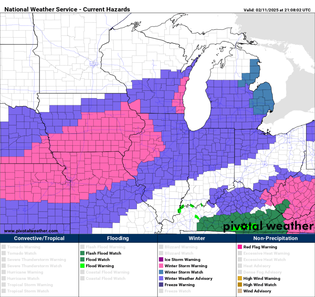
Our local NWS office mentioned there being enough confidence for a low-end Winter Storm Watch for the northwest edge of our area. However, confidence in a Winter Weather Advisory for most of the remaining counties was too low early this afternoon—but I suspect we will get one tonight or tomorrow. We didn’t get a Winter Weather Advisory; we got a Winter Storm Watch. The greatest likelihood of reaching winter storm-level criteria remains to our northwest, but significant travel impacts are expected locally nonetheless. If yesterday’s forecast pans out, we’d see things start as sleet and freezing rain. This would lower snow totals but create an initial layer of ice that would eventually be covered with a few inches of snow. We would see less sleet and ice and more snow if more recent runs were verified.
Amounts
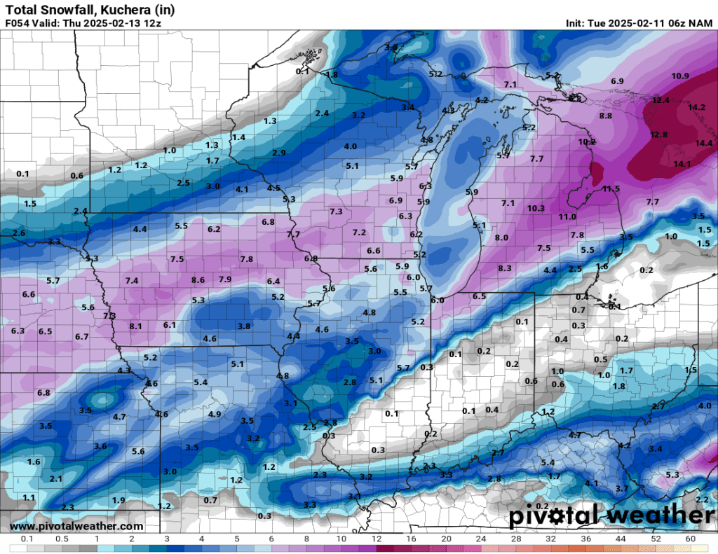
There will be a sharp gradient between several inches of snow and an icy rain/snow mix. Several models have this gradient dividing Elkhart County. I don’t know if that will happen, but 30 or so miles will be the difference between moderate snow accumulations and mostly slush.
The exact storm track will make a big difference, given that tight gradient. Unfortunately, with such a small range making such a big difference, we probably won’t have a good idea of where the snow and slush will set up until a few hours before things get going on Wednesday.
I’ll adjust this over the next 36 hours, but my best guess right now is 2-5” total—with a heavy lean on the lower end. All of this remains true, but based on overnight data I’m updating potential totals to 3-6”.
Timing
I have good confidence in the storm’s timing, regardless of its specific track. Snow will begin early Wednesday afternoon and intensify Wednesday evening. It should be moderate to heavy at times Wednesday night before slowing down Thursday morning and tapering off entirely later Thursday. No changes here.
Summary
I think this will go down as yet another near miss. I expect a few inches of snow Wednesday afternoon, and it could come down pretty well at times with reduced visibility. However, I would be very (pleasantly) surprised to see more than two or three inches on the ground by Thursday morning. I’ll keep an eye on things and update as needed.
And yes, there is a chance for more snow on Saturday, but I suspect a similar storm track to Wednesday’s event. Let’s get through the next 60 hours before we spend too much time on this weekend.
In general, models have shown a subtle shift to the southeast, which places Goshen in a more favorable zone for snow accumulation. Sleet and freezing rain is expected either way.
Thursday night and early Friday morning will be very cold. With our new blanket of snow (regardless of how thick it ends up) and clear skies expected overnight Thursday into Friday, temperatures will likely drop to near zero. Fortunately, winds are expected to be nearly calm, so windchills won’t be much lower than the air temperature. We should warm up to the upper 20s by Friday afternoon.
Saturday looks snowy, and more travel impacts are expected. We will discuss this on Thursday. If you have travel plans on Saturday, don’t cancel them yet. Just plan on adding extra time to arrive safely.
-pw

Leave a comment