
Saturday PM Update
I held off on updating to make sure I got the latest model runs, and the eastern trend has continued to push any snow away from us.
We’ll be lucky to see an inch or two by tomorrow. Nonetheless, it will be breezy and cooler tomorrow, with temperatures slowly sliding essentially from now until tomorrow night, when they reach the mid to lower 20s, before really tanking late tomorrow night. By Monday morning, we’ll be sitting in the single digits and struggling to reach the teens Monday afternoon.
Saturday AM Update
Last night’s snow was beautiful. I walked out of the GHS Boys’ basketball win over Wawasee just as the snow picked up. We ended with a solid 2” from that ~4 hours of snow, which is pretty impressive.
In the last update, I mentioned dry air “winning out,” leaving behind a little freezing drizzle and then drizzle, which is panning out nicely. In fact, the skies won’t be clear, but I can see thin spots in the satellite view of our west and south, and they should make their way to us over the next few hours.
The rest of today looks relatively calm, with temperatures slowly climbing into the mid- to upper 30s. By this afternoon, if not a little sooner, any precipitation we see will be liquid.
Tonight is where things get interesting. A strong cold front will pass, bringing a chance for snow (more on that below), gusty winds, and a flash freeze. Any snow we get will get whipped around overnight and into Sunday by 30-40 mph wind gusts. The quick dip in temperatures well below freezing, plus moderate wind gusts, could lead to poor visibility and slick roads for much of the day Sunday—especially if we get some melting today. Sidewalks, elevated, and untreated surfaces will be slick tomorrow morning, so be careful on your way to church, breakfast, grocery shopping, etc.
Last night, I mentioned that the CAMs (convection-allowing models—short-range models that factor in more current conditions than the global models can) were forecasting moderate to heavy snow on Sunday. The NAM (North American Model) was one of those models that picked up on heavy snow locally. However, since my last update, a steady trend has been pushing the snow further and further east. You can see for yourself below.
I suspect we will see some light snow tomorrow, only an inch or two, and it won’t fall all day. But it will be very cold, so the snow should be powdery and light, which will make it easily blown around by winds that are still expected to gust to around 40 mph at times tomorrow.
We’ll probably see another Winter Weather Advisory for early tomorrow morning through most of tomorrow night to account for blowing snow and a flash freeze. That would likely come with the next shift at our local NWS office this afternoon.
It won’t be pleasant tomorrow, but if you take the standard winter driving precautions (slow down, give yourself extra time, and for goodness sake, clear off your windshield and back windows—don’t forget the headlights, too), you should have no trouble running errands tomorrow. That being said, today would be the best day to get things done around town if possible.
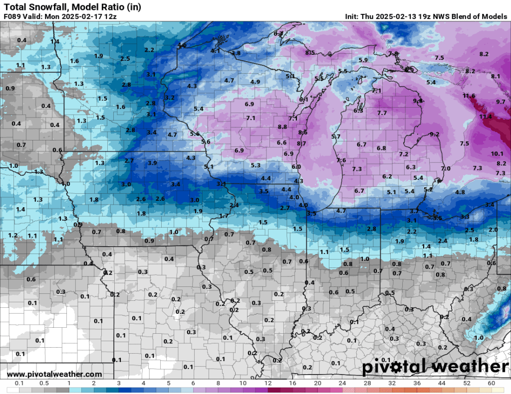
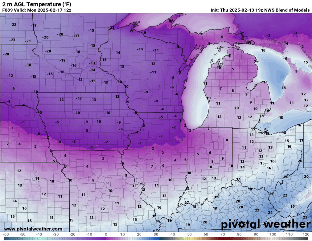
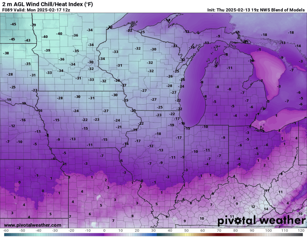
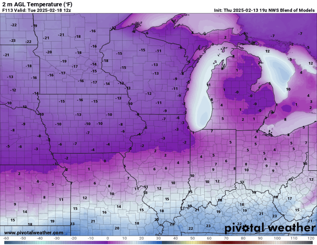
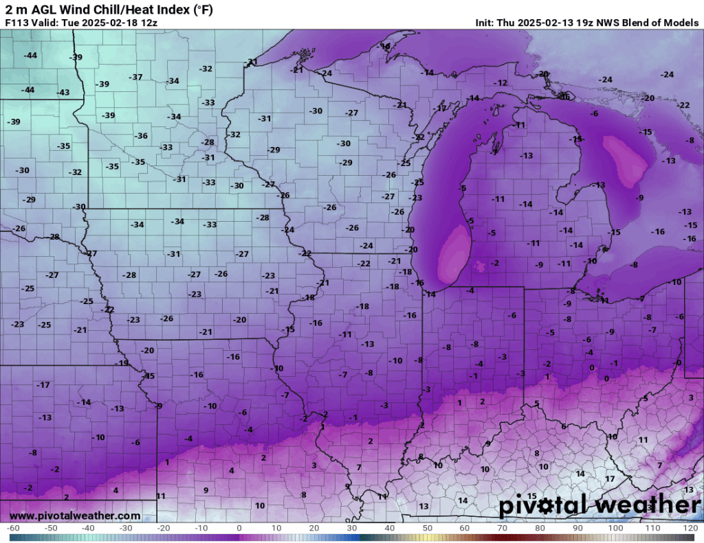
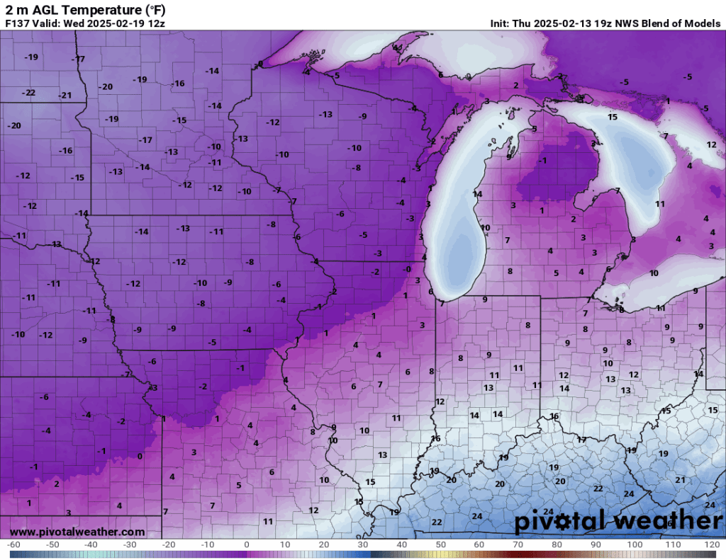
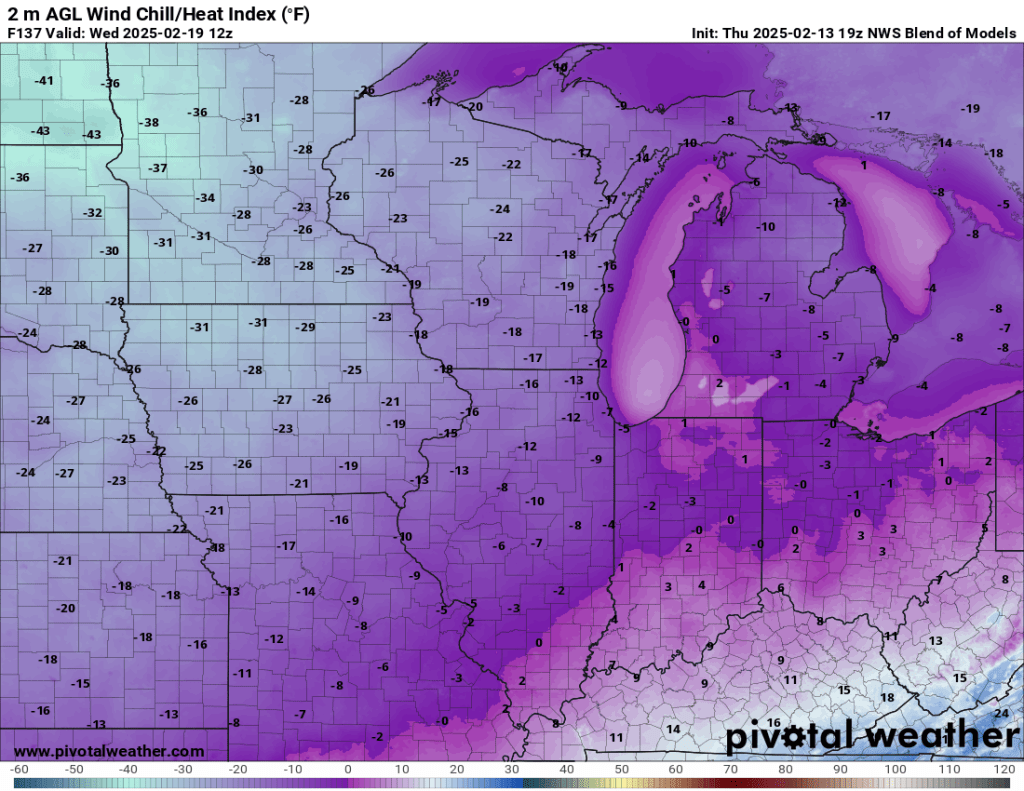
Everything winds down by Monday, and we’ll be just plain cold for the first half of next week. Temperatures are forecast to fall into the single digits overnight and only rise into the teens in the afternoon. Wind chills will range from 0°F to perhaps -15°F at times. If we see more snow, these temperatures will have to be adjusted slightly lower.
Next update will come tonight, stay warm!
-pw
Friday PM Update
Happy Valentine’s Day—especially to my incredible wife, who has been known to occasionally read these.
There have been some notable changes to the forecast over the last 12 hours. The first is that tonight’s snow will likely be less intense than expected. An inch or two of wet snow can be expected between roughly 7 PM tonight and 6 AM tomorrow. It may not look like much when you wake up tomorrow, though, because of the rising temperatures leading to the compaction of the wet snow. Temps will slowly rise into early tomorrow morning and peak in the mid to upper 30s tomorrow afternoon—meaning we will see more light rain than snow or freezing drizzle during the day tomorrow, which would eat away at any snow we get tonight.
Another change to the forecast is the increased likelihood of dry air “winning out” tomorrow, which may eliminate the rain now in the forecast for tomorrow.
Temperatures will quickly fall overnight Saturday into Sunday, and whatever melting/liquid precipitation we get may flash freeze, leading to slick roads Sunday morning. The rest of Sunday is a bit of a wildcard. The CAMs are hammering snow Sunday into Monday to the tune of several inches. This is a new trend, and we will need to get through tonight and tomorrow’s model runs to see if this trend continues. More on this in the next few updates.
Friday AM Update
There has been only one change to this weekend’s forecast since yesterday’s post: temperatures tomorrow afternoon are expected to get a few degrees warmer now, which would make for a plain old cold light rain and drizzle for several hours tomorrow instead of freezing rain or drizzle. The remainder of the forecast below hasn’t changed.
Original Post
The last storm certainly got a lot of hype and may have underwhelmed some folks. The final call was 3-6”, and I have just a hair over 3” in my yard. There were plenty of models with considerable agreement touting hefty totals early on.
This is where experience comes in. Those of you who have been with me since the beginning know that the totals will always be the highest several days out, and as the storm approaches, models will average out, and the totals will lower. Our last storm was a great example of this.
That brings us to our weekend storm. There is a notable difference with the forecast for this weekend—the snow will be spread out over three days and mix with rain for several hours. Snow is expected to begin Friday night, and it could come down pretty hard at times. Accumulations will be light (1-3”). You can expect the most significant disruption to travel in this time frame.
By early Saturday morning, temperatures are expected to rise just enough to likely see some drizzle or freezing drizzle mix in. By later Saturday morning, a rain/snow mix is expected. This should taper off into Saturday night before a reinforcing shot of cold air arrives Sunday, bringing another inch or two of snow.
The cold air is expected to kick up some lake-effect snow early next week, but it will likely stay north of the Indiana/Michigan state line. We will need to keep an eye on temperatures and windchills next week. Lows in the single digits would promote the possibility of windchills well below zero.
It looks very cold at this range, but it is probably not quite cold enough to cause widespread school delays or cancellations. That could change as we get closer, and it is worth keeping an eye on.
I’ll have another update tomorrow morning. Enjoy the sunshine this evening and tomorrow!
-pw

Leave a comment