
Wednesday PM Update
There have been no significant changes to the forecast for another 12 hours or so. Totals have come down across the board, which I think speaks to the continued uncertainty regarding the setup of the lake effect. Will one dominant band set up with higher totals for a smaller area, or will there be multiple bands and lighter but more widespread totals?
Ultimately, I’m not sure it matters. If one band does form, it is almost certain it won’t be here, resulting in little to no snow for us. If there are multiple bands, we would see some snow but might be looking at 2-3” at best, and probably more like an inch or two.
As of 6 PM, we are still waiting for that one band to develop. Right now, multiple cellular bands aren’t doing much locally. It is probably a different story closer to Lake Michigan (that’s you, I94 corridor), and this is where I suspect most severe travel issues will stay.
Never say never with lake-effect snow, but I don’t think this will go down in our books as much of anything. Elkhart County was added to the Winter Weather Advisory, effective until 7 PM tomorrow. This wasn’t for snow accumulations as much as it was occasional blowing snow and reduced visibility with the cold temperatures, wind, and fluffy snow.
We will see some snow showers tonight, and they could sometimes reduce visibility, but again, I do not expect significant totals (I’d love to be wrong about that!) If you get caught in a snow band, slow down. If you plan to travel west or north tonight, plan for extra time and potentially hazardous travel.
Wednesday AM Update
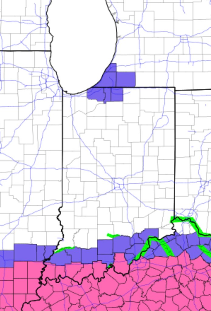
There are no significant changes to the forecast from last night. Unfortunately, that means confidence hasn’t grown much since last night. As expected, LaPorte and St. Joe counties in Indiana and Berrien county in Michigan were highlighted with a Winter Weather Advisory (purple). Cass County in Michigan was also added. 2-6+” is expected in these areas. I still put the odds of this playing out around 80%. The odds of us seeing moderate to heavy snow are about 10%, and the odds of something else happening (multiple/cellular bands, snow further west, snow stays north or east, snow is a bust) are about 10%. Elkhart county could be added to the advisory area if models change over the next 6–12 hours, but the best chances for moderate snow are still just to our west.
The significant winter storm can be seen along the IN/KY border below, with winter weather advisories and winter storm warnings (pink). That is the storm that, as it passes, will draw air toward it, shift winds out of the northwest off the lake, and promote the development of lake-effect snow tonight and early tomorrow. Everyone sees an inch or less out of the storm this afternoon/evening before the lake effect sets up.
Original Post
A potent bout of lake-effect snow is expected over parts of northern Indiana starting tomorrow afternoon and lasting into Thursday. Several factors could come together to produce one or two dominant bands that could potentially produce 6+” of snow for locations caught beneath them for extended periods of time. Current thinking keeps most snow in LaPorte and St. Joe counties in Indiana and Berrien County in Michigan.
Some models are swinging the snow bands further east into Elkhart County. If things come together, the snow band could extend well inland regardless of where it sets up.
Confidence in everything lining up just right is low. Confidence in general amounts and locations is medium—but it will come down to the last minute before we have a good idea of exactly where the band(s) will develop. And as always with the lake effect, twenty or thirty miles makes a huge difference. It could snow heavily in Mishawaka, and the sun could shine in Goshen.
Right now, I think the heavy snow will stay one county west of us. If you are traveling west tomorrow, you will drive through moderate to heavy snow by tomorrow afternoon and evening.
Usually, with events like this, the snow bands eventually shift our way, but not until they weaken. I put the odds of this playing out around 80%. The odds of us seeing moderate to heavy snow are about 10%, and the odds of something else happening (multiple/cellular bands, snow further west, snow stays north or east, snow is a bust) are about 10%.
It will be cold tonight and tomorrow, regardless. As a result, any snow we get will be light and fluffy and blow around easily. Take it easy, especially tomorrow night, in areas with the heaviest snow.
-pw

Leave a comment