
After several weeks of bitter cold, snow, ice, fog, freezing rain, and blowing snow, we are finally in for a break. How long the break will last is to be determined, but we will have at least a few days of above-normal temperatures.
The tradeoff will be a stiff breeze throughout, but as mentioned a few posts ago, we will likely make a run at 50°F in the next week, potentially more than once. There are a few chances for rain, but at this point, I don’t see anything more than 0.25” falling in a 24-hour period.
With the ground frozen and a few inches of snow, a lot of rain in a short period of time would cause problems—thankfully, I don’t see anything like that happening. If you recall, that was the set-up in February 2018 when we had historic flooding in Goshen. We received over 6” of snow with the soil frozen, and less than a week later, we received up to 8” of rain in less than 48 hours.
Again, I want to reiterate that nothing like that will happen in the next week. I just wanted to point out that a few of the ingredients are present, and until we shed the snowpack and thaw the soil, we will be susceptible to at least minor flooding should we see any periods of heavy rain—this was a concern I laid out in my Winter Outlook back in November, and I fear it is going to become the norm. It doesn’t seem like we get much of a transition between seasons anymore.
Okay, back to the week ahead. While the next 5-7 days look warmer than usual overall, the latest CPC outlooks tell us that we shouldn’t expect it to last much longer.

Beyond that 5-7 day range, a return to normal or below-normal temperatures can be expected. I want to point out that the eastern and primarily northeastern part of the continental United States is expected to see normal or below-normal temperatures in the 8-14 day range. Simultaneously, Alaska is expected to see well above normal temperatures.
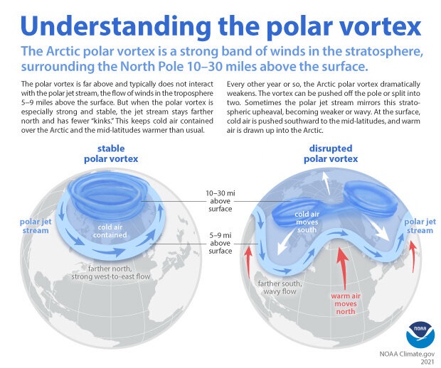
This pattern was discussed in my polar vortex blog post, and it is setting up again. This pattern is based upon “Rossby Waves” and is being driven by cooler-than-normal temperatures in the Pacific Ocean, commonly referred to as “La Niña.” The polar vortex is like a top, spinning above the North Pole. Just like a top, when the spin becomes weak, it starts to wobble. That wobble leads to our Rossby Waves.
The Rossby Waves are enormous and take considerable time to pass, but you’ve noticed that passing without noticing it all winter. Since December, we’ve seen roughly two-week periods of rough weather followed by roughly two-week periods of relative calm. That pattern continues today as we enter one of the more calm stretches.
So, what does this mean for the spring? After all, meteorological spring arrives on Friday. It means until the top, known as the polar vortex, strengthens and tightens up its spin, these Rossby Waves and the associated rough, smooth, rough pattern will likely continue.
This pattern also lends itself to intrusions of cold air, and while we will still see warm days, the overall pattern would be for a cooler-than-average spring. With the extended periods of active weather, we will likely see a wetter-than-usual spring as well. The CPC outlook for March was released a few days ago and mirrors these expectations.
Essentially, until the polar vortex tightens up again, we should expect to see the on-again, off-again pattern of active weather followed by calm weather every two weeks or so. The length of the day and the angle of the sun will work together to push the cold air north, which will help tighten the polar vortex again but also set the stage for potential severe thunderstorms.
We are almost to the beginning of severe thunderstorm season around here, and if there is extra cold air to work with, we could see more severe storms this spring than we have in the last several springs. This could also mean more spring snow. It all depends on the storm track. Suffice it to say, I expect our active pattern to continue well into spring, and we are not done with snow.
-pw

Leave a comment