
Early Wednesday PM Update
The main focus for severe weather has absolutely shifted well to our south. In fact, parts of our area have been trimmed out of the enhanced risk area thanks to the extended period of cool rain and embedded thunderstorms. However, at 3:45 PM, the warm front is still trying to get to us. It is between Lafayette and us now. There are some questions as to how far north it will make it and how long it will last before the cold front approaches. It still appears more likely than not that the warm front will arrive before the cold front and briefly bring temperatures in the 60s and dewpoints in the 50s, if not 60s as well.
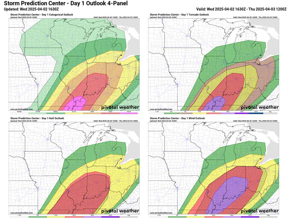
If that warm front makes it past Goshen before the cold front, we would still be in play for all modes of severe weather, similar to Sunday evening. Storms are expected to form a line and will have the potential to produce strong to severe wind gusts. Hail is also possible, but would likely be 1″ in diameter at most. A few spin-up tornadoes can’t be ruled out either. The time frame for our severe weather threat locally appears to be between 6 PM and 10 PM, but my best guess now is between 7 PM and 9 PM for the bulk of the heaviest weather to move through.

The radar is relatively quiet locally. Once things start to pop, we’ll have an even better idea of timing and intensity. When storms begin to fire, I’ll switch to Facebook posts every 45 minutes or so. We aren’t out of the woods yet, but this setup looks less impressive in our immediate area.
Wednesday AM Update
Rain and storms this morning and into early afternoon may put a damper on our chances for big storms this evening. However, if we see clearing or even broken clouds this afternoon, that could be enough to recharge and then supercharge the atmosphere and produce more severe weather this evening. Severe wind gusts remain the most likely threat. Also, much further south, a tornado outbreak is expected.

Tuesday PM Update
An area of moderate risk was added to the enhanced risk today, but it is well south of our region.

Our region is still in play for strong gusty winds, heavy rain, and potentially hail up to 1.75” (golf ball). Last night, I mentioned some concerns about rain and a few thunderstorms early on Wednesday, using up some ingredients and limiting the intensity of storms tomorrow evening. That concern still exists, and I think there is a good chance we will see rain and non-severe storms in the first half of the day tomorrow.

The biggest question now is if we will clear off tomorrow afternoon. Much like last Sunday, the intensity of the storms tomorrow night will depend on how much sun we see. The sun would quickly raise temperatures and increase humidity—two key storm ingredients. Our atmosphere is expected to have several other, far less common “ingredients” as well, but without the added energy from the sun, we might not see as much severe weather. One possibility is the added kinematics from the passing cold front could be enough to overcome a lack of sunshine and still produce severe weather.
As you can see, even 24 hours out, considerable uncertainty still exists. I think the severe weather threat locally is still legit. However, the possibility of not quite a busted forecast but far less widespread severe weather is low but rising.

The timing will be similar to Sunday, with storms expected to roll through between 5 PM and 10 PM. We should be able to narrow that down by lunchtime tomorrow, when I hope to post my next quick update.
Monday PM Update
The Storm Prediction Center (SPC) has maintained and expanded an area of enhanced risk that fully encompasses the entire state of Indiana. Enhanced risk is 3/5 on the SPC scale, and the latest update this afternoon mentions the strong potential that parts of the Enhanced risk area could be upgraded to Moderate risk (4/5) before Wednesday’s event.
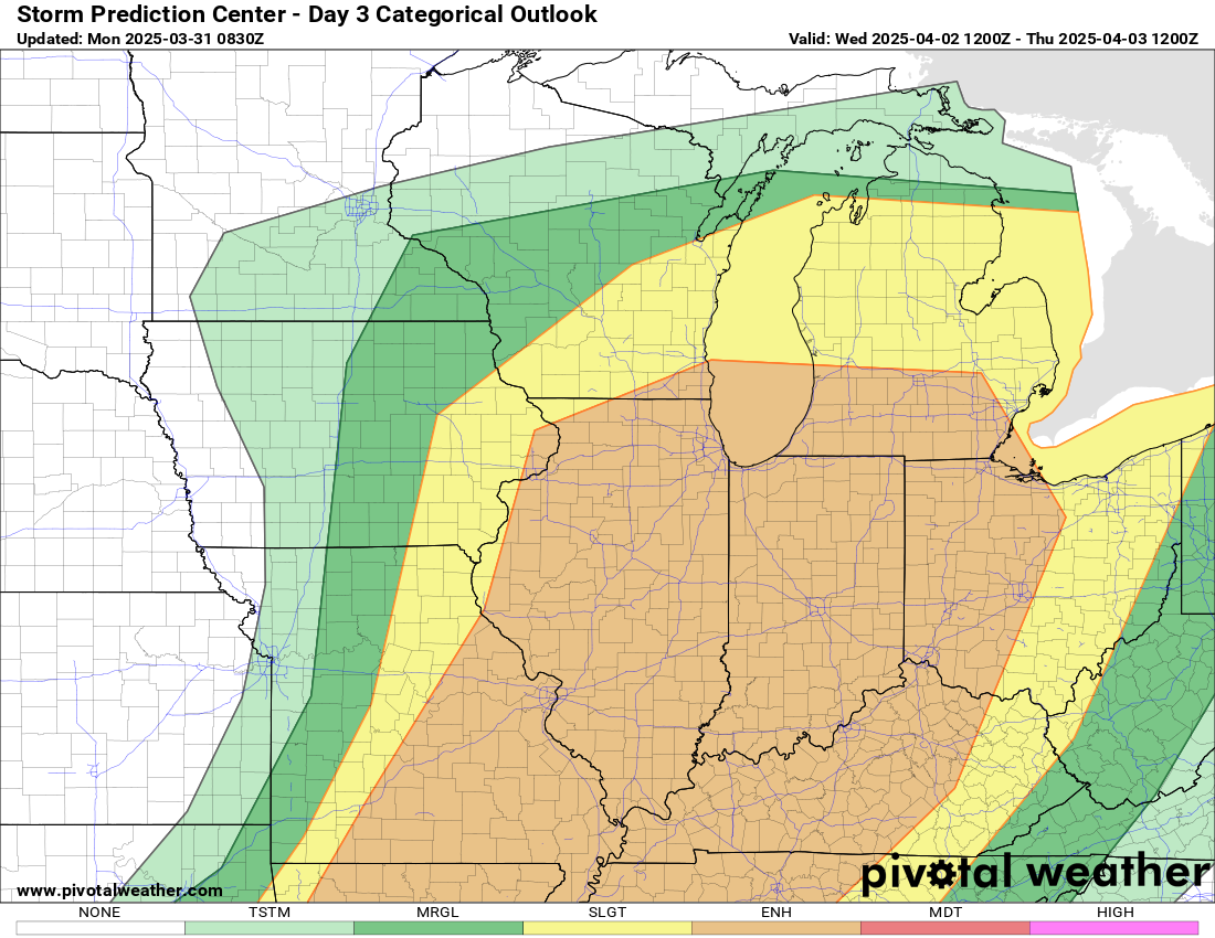

The setup for Wednesday is eerily similar to this past Sunday afternoon and evening. There is some question about storm development out ahead of the front absorbing some of the “ingredients” for later storm development along the front itself in our neck of the woods. Regardless, another widespread high wind event is possible, and even though we are still 48 hours away, it is worth paying attention to. I’ll have another update or two tomorrow.

Leave a comment