
Thursday PM Update
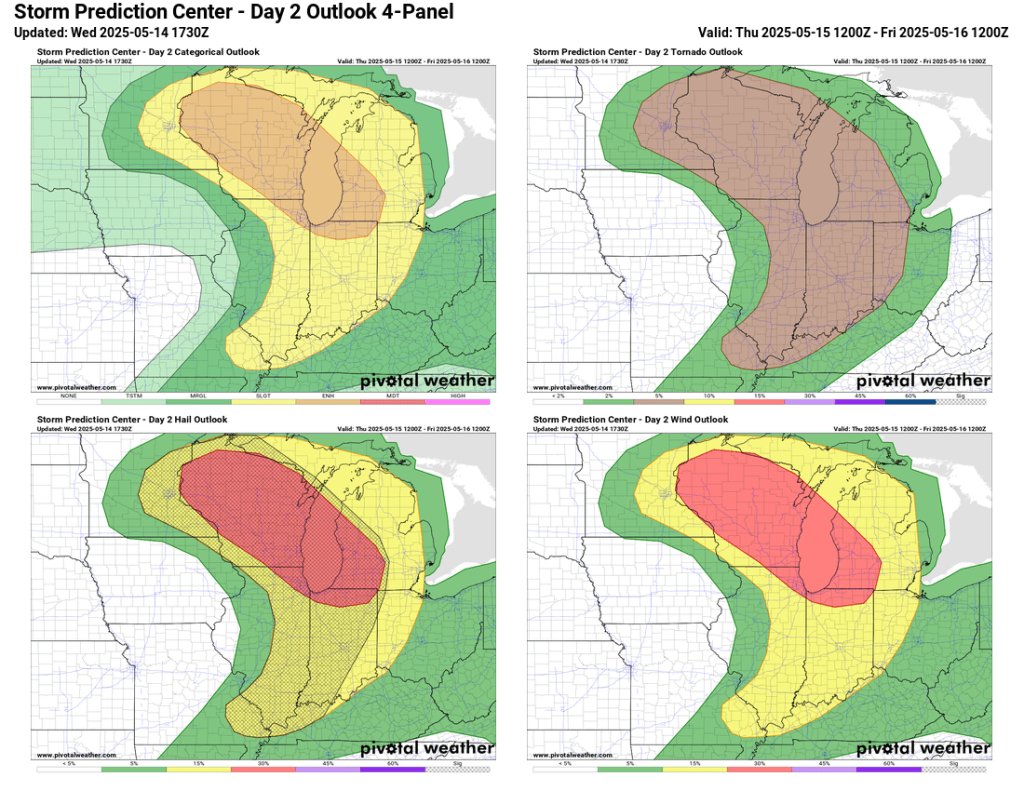
The latest update from the Storm Prediction Center (SPC) has expanded the area of enhanced risk further south, putting us in a more favorable zone for severe weather. High-risk areas for tornadoes, severe wind gusts, and severe hail have been expanded as well, and all include Goshen.

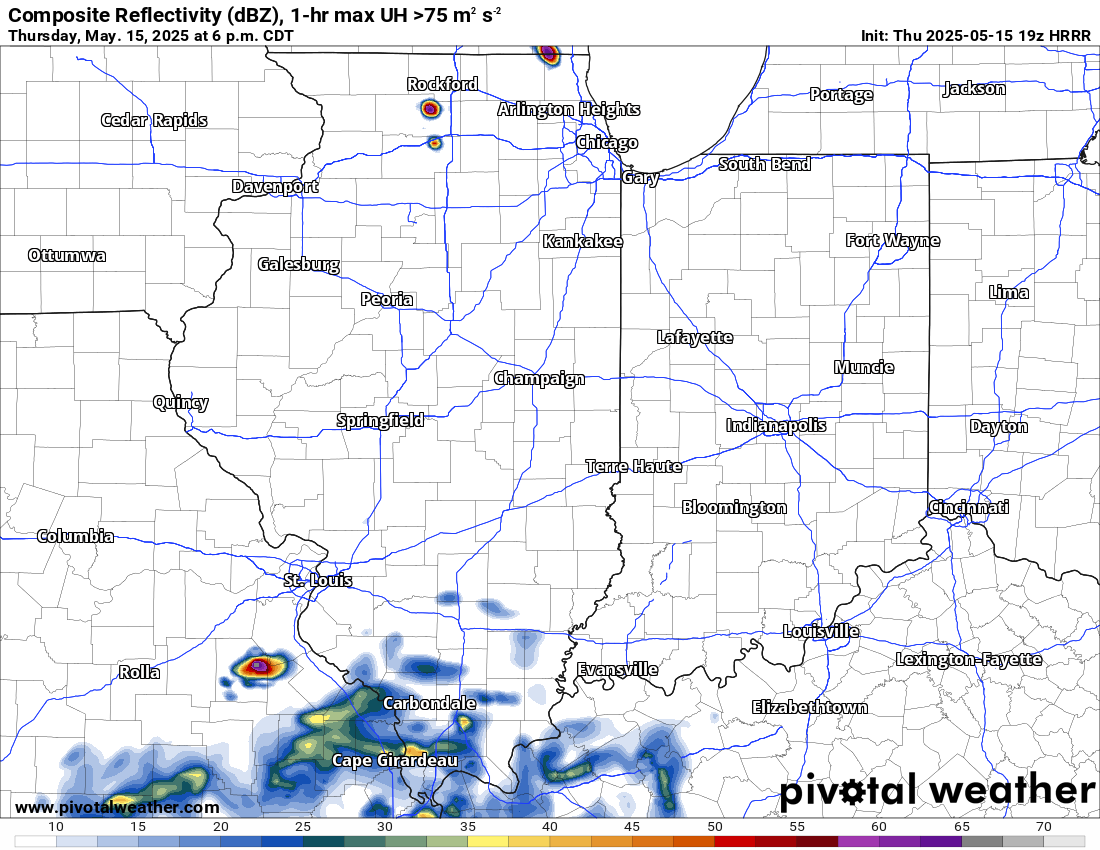
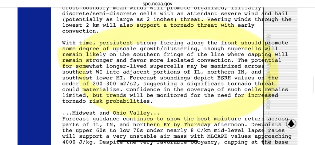
In general, not much has changed from last night’s post. There is no shortage of sunshine, heat, or moisture for storms to work with. As of 4:15 PM, the temperature in my backyard is 84°F, with a dew point near 70°F, making it feel closer to 90°F. Storms won’t arrive until close to midnight. They should begin to form to the west and slightly southwest between 5PM and 8 PM.
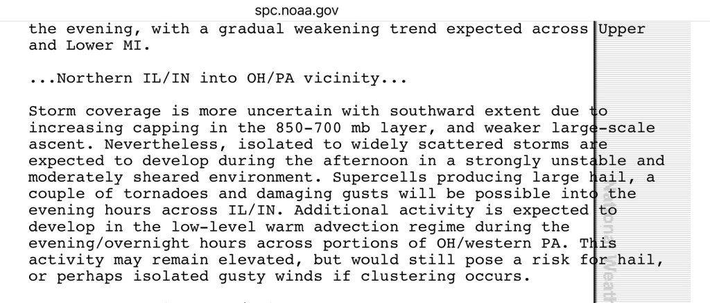
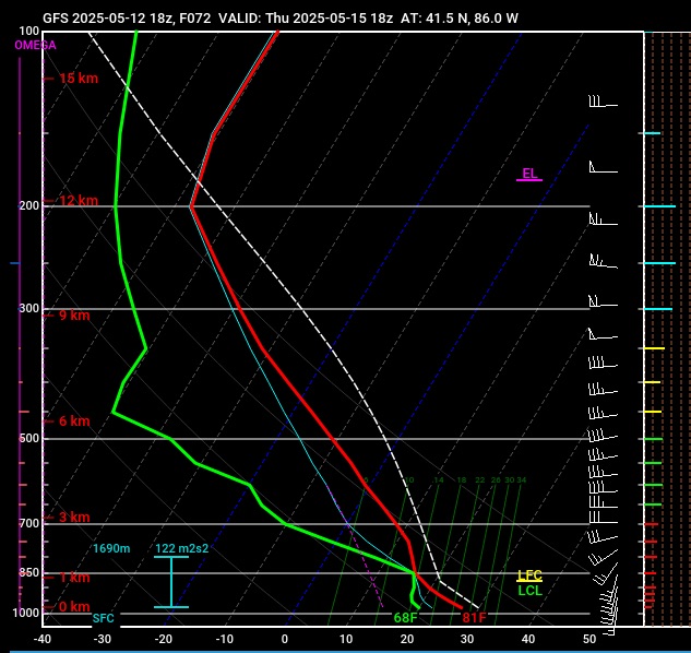
Initially, storms will likely be more isolated (supercells?) before quickly consolidating into a cluster or line. If they happen to develop further west (closer to us), our risk for hail increases. If they develop far enough west and congeal into a line, there is still a risk for hail, but the straight-line wind gusts would be the biggest concern in this scenario. Most models have the latter playing out. The HRRR has been pretty consistent over the last 24 hours. You can see the latest run below. It is…explosive.
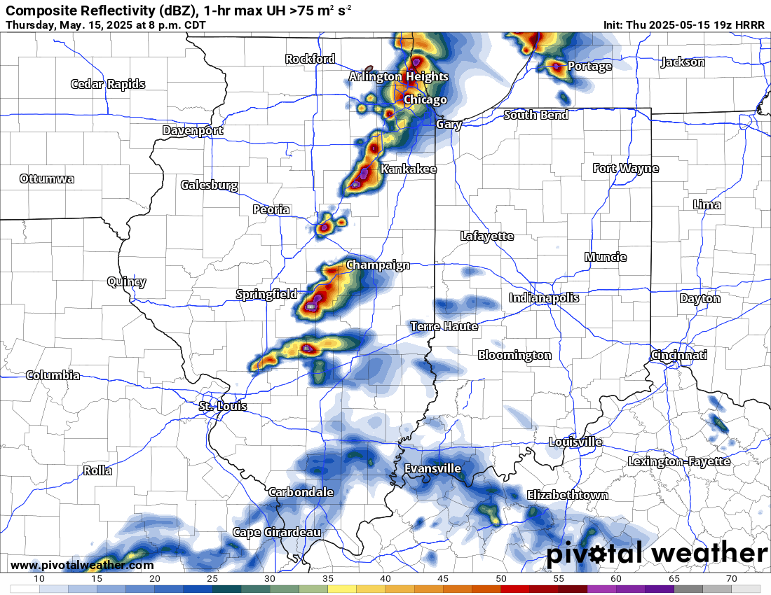
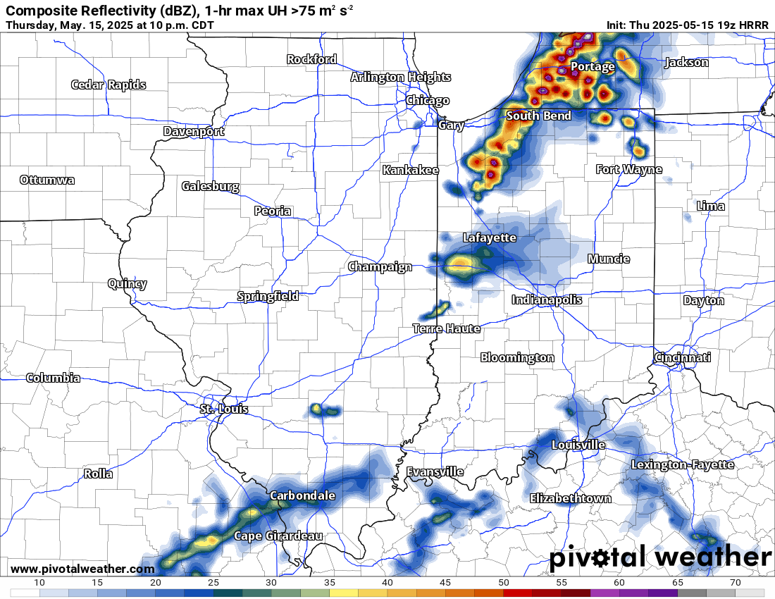
I think the storms probably arrive a little earlier than this, but regardless of when they do—assuming we do, in fact, break the cap—these storms will pack quite a punch. This is by far the best set-up for severe weather we have had this year, and one of the better in the last several years. Storms that develop tonight will have a good potential to bring high-end severe weather.
The timing of the storms is concerning because many of us will be heading to or already in bed by the time things get going. Therefore, ensure you have a means of receiving alerts with sufficient warning to seek shelter if necessary. Charge your batteries now, just in case.
We Midwesterners, including myself, have a tendency to dismiss storm warnings, and many of us will go to the window or out in the driveway to see it rather than take shelter. Tonight is one of those times when you should heed the warnings. And please don’t go storm chasing. It will be dark, and the only thing you will see if you find a good storm is damage to your vehicle or worse.
Updates for the rest of the evening will come via Facebook.
-pw
Wednesday PM Update
I’m not one for hyperbole, but I will lead by saying the latest data makes me excited and concerned for tomorrow evening. In the last update, I mentioned that the atmosphere tomorrow evening will be primed to explode (mentos shaking in a bottle of Diet Coke) quite literally, and that is as true as ever. What has changed and concerns me is that the cap we discussed in the last two updates may break earlier than expected locally.
We will have to keep an eye on the radar late tomorrow afternoon and evening. Anything that develops tomorrow afternoon and evening not only has the potential, but is highly likely, to become severe. We haven’t seen legitimate supercells in this area in quite some time, and the current data supports a few supercells rumbling through northern Indiana tomorrow evening.
A supercell is a large, single storm that often rotates and can produce large hail and tornadoes. Tornadoes are possible tomorrow, but our most significant risk of large hail in roughly 5 years is coming tomorrow afternoon. 2.0” diameter hail or bigger is possible in any supercell that develops tomorrow. I took a video from the south side of Goshen during our last big hail storm almost exactly 5 years ago.
Have a way to get warnings tomorrow evening. There is still a chance that the cap stays in place and we see absolutely nothing. However, 24 hours ago, the odds of severe weather or nothing seemed to be about 30/70. Now, I’d say those numbers are closer to 50/50. We will have time to prepare, as storms are not expected to roll through until sometime between 6 PM and 10 PM. I’m not sounding the alarm or trying to create panic, but any storms that develop tomorrow must be taken seriously.
There are some significant x-factors tomorrow that just aren’t all that common in mid-May. Temperatures tomorrow are expected to be 10-15°F above normal in the low to mid 80s—not unheard of, but not common either. Also of note, our dew points (which measure the amount of moisture in the air and are an exceedingly better indicator of “humidity” than relative humidity percentage alone) will be at tropical levels in the 70-75°F range.
To put that in perspective, the current dew point in Key West, Florida, is 73°F, Miami is 66°F, New Orleans is 66°F, and Houston, Texas, is 72°F. It will be just as humid, if not more, tomorrow afternoon in northern Indiana as it is along the Gulf of Mexico today. Again, that does happen a few times per year, but not usually in mid-May.
Another factor is that even though it looks more likely that potentially severe storms will develop, coverage will likely be limited. Tomorrow will be all or nothing, with any storms that develop being widely scattered.
I’ll let the data come in over the next 24 hours before making another update to this post. I would not be surprised to be under, or soon be under, a tornado watch 24 hours from now.
Tuesday PM Update
The SPC has highlighted most of Wisconsin with a moderate risk of severe weather on Thursday. Thanks to an eroding cap earlier in the afternoon, there is a much better chance of storm development.
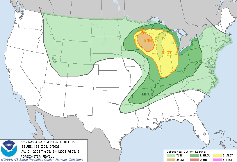
Goshen is still firmly within the slight risk area for Thursday evening and night, but this risk is highly conditional on the temperature inversion (cap) breaking. The NAM model is bullish on an explosive atmosphere and just as bullish on a strong cap, keeping a lid on it through the evening.

If the cap breaks earlier than expected (current thinking is Thursday night), there could be explosive development of discrete cells capable of producing very large hail and a few strong tornadoes. For now, though, the data suggests we see little, if any, precipitation all day Thursday and well into the evening. If that pans out, our risk of severe weather will decrease without the heating of the day.
Again, with this most recent data, despite the potential for an explosive environment, I believe we stay dry through Thursday evening or night, limiting our severe weather potential—more updates to come.
Original Post
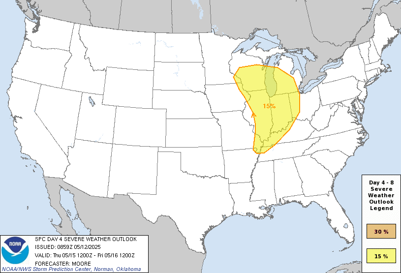
Once again, the SPC has highlighted our area several days in advance. Thursday could have the potential to be a very stormy day.
All thunderstorms need the same three general “ingredients”: moisture, instability, and a lifting mechanism (or trigger). Despite having two of the three by Thursday, we may struggle for our trigger to be strong enough to break a strong “cap” over the lower layers of the atmosphere.
Think of dropping a few Mentos in your bottle of your favorite soda. Then imagine that bottle has been rolling around the bed of a truck, driving through a twisting, turning, bumpy road. After a few minutes of shaking, that bottle is ready to explode. But, as long as the cap stays in place, it won’t. However, we all know what will happen the second you remove that cap.

In the atmosphere, a temperature, or capping, inversion (“cap”) occurs when air aloft (up to 10,000 feet or more) is warmer than the air at the surface trying to rise through it. Temperature inversions are common in spring, summer, and fall mornings before things warm up near the surface.
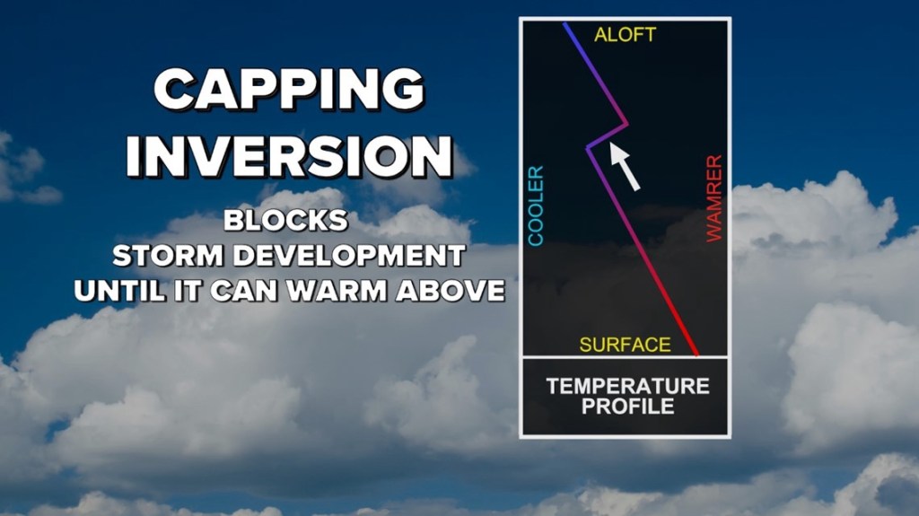
You can have all the best storm ingredients imaginable, but if that temperature inversion (cap) remains in place, there won’t be severe weather, probably not even rain!
Why is this relevant? Well, you can look up forecast soundings for Thursday just like in the “capping inversion” figure above.
There is some concern regarding a strong cap Thursday morning into the afternoon that would inhibit any storm development. However, things look pretty robust right now, and at this stage (several days out—let’s not get too worked up either way), things look to have the potential to be nasty—if we can break the cap. It will be hot and humid for the first time this year, providing plenty of moisture. Sunshine is also expected, which should give plenty of instability (potential energy—think shaking the bottle of pop). A lot will depend on the timing of our trigger (front) and how strong our temperature inversion (cap) is.
We cannot do much now, but we can wait as more data comes in over the next 48 hours or so. In the meantime, we will probably see a few more clouds over the next two days, with occasional chances for scattered showers and thunderstorms—more “splash and dash” showers than soaking rain are expected, though. Stay tuned for updates on Thursday’s storm potential.
-pw

Leave a comment