
Update 5 (Monday AM, 11/10/25)
It looks like we picked up another inch or two since 6 PM yesterday in my backyard, thanks mainly to that burst of snow between 7:30 and 8:00 PM. This has me right around 4” total. As is often the case with lake effect, some of you in town or close to it may have a little more or less.
Initial reports out of South Bend are 6-8”, with 7-10” around La Porte county. A few isolated spots to our west could have even more.
We should be quiet most of the day, and I’ll be monitoring the progress of the lake effect band shifting east out of Chicago and back our way. It is starting to look like winds may stay more northerly than northwesterly, which would once again keep the bulk of the snow to our west tonight.
More updates to come. We are under a WINTER WEATHER ADVISORY until 1:00 AM Tuesday.
Update 4 (Sunday PM, 11/9/25)
We are currently seeing the heaviest snow all day and if it snowed like this all night we’d be talking about half a foot of snow or more and widespread school cancellations. Unfortunately, this is probably it for the real good accumulating snow for tonight in Goshen and it will taper off over the next hour. We will see snow off and on tonight, but the lake effect is already shifting west and taking most of the accumulation with it. Chicago’s turn is next!
The next phase for us to keep an eye on is tomorrow afternoon and evening. There is a chance for more accumulating snow as the lake effect bands shift back to the east and favor our area.
Unfortunately, when this happens, the winds at different layers of the atmosphere often vary and shred the singular dominant band of snow into lighter, multicellular bands spread out over a larger area. This leads to lower amounts but can still lower visibility at times, and could disrupt the PM commute locally tomorrow. Tomorrow morning should be fine—just take it slow.
Update 3 (Sunday AM, 11/9/25)
Temperatures overnight were just low enough that rain changed to snow sooner, allowing for a bit more accumulation. It’s heavy wet snow, and it is already compacting under its own weight, but elevated surfaces had 2-3” on them in my backyard about an hour ago. Grassy surfaces have an inch or so of coverage, and paved surfaces are at least partially covered.
We’ll see snow showers, but the accumulating snow is done for now. All eyes are on the lake effect snow band stretching north to south along the entirety of Lake Michigan this morning.
If this slides far enough east for any decent length of time, we could see several inches of accumulation (2-4+”). Still, if it doesn’t, we won’t see much of anything until winds shift again late tomorrow and push any remaining lake effect back our way.
There are still a lot of “ifs” in our forecast for accumulating snow, enough that I’m sticking with my 1-3” forecast, meaning I’m confident in another inch or so falling in Goshen over the next 36 hours. I am cautiously optimistic that we could see the aforementioned additional 2-4” with some lake effect snow bands here later today and into tomorrow, but much less confident.
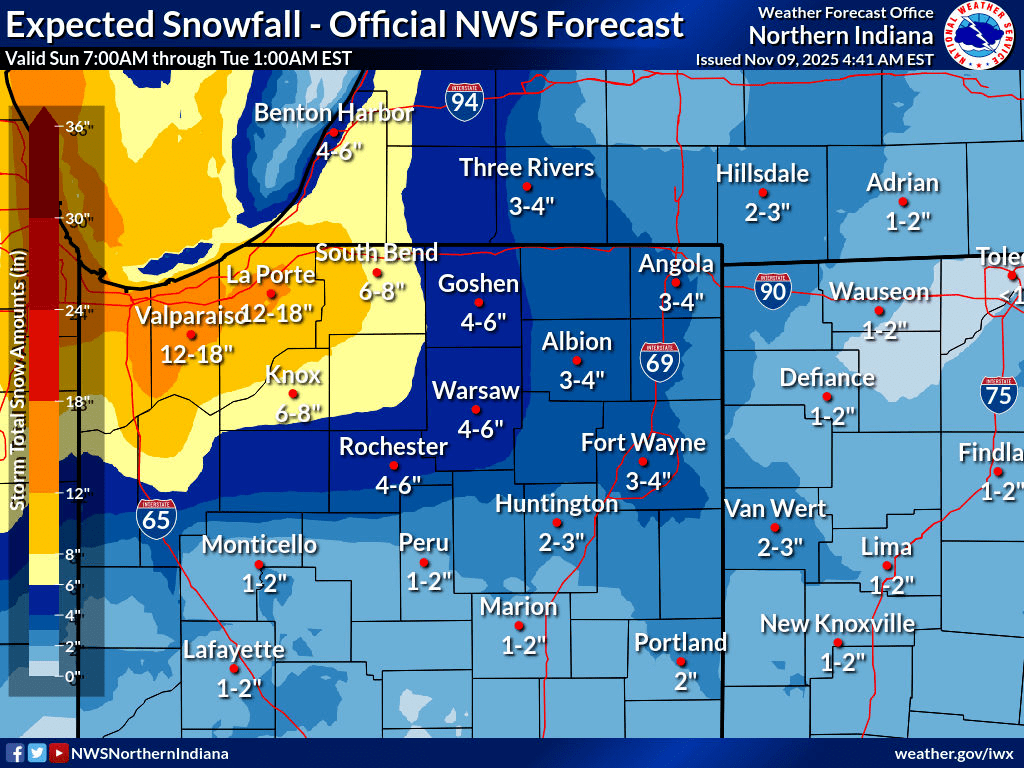
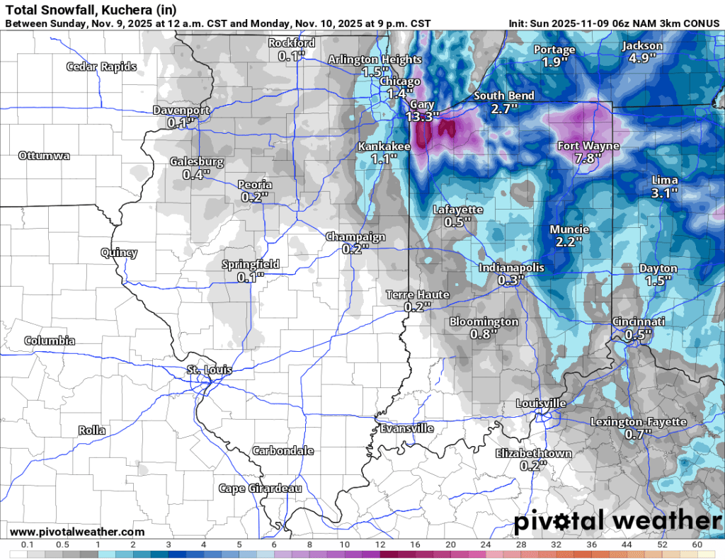
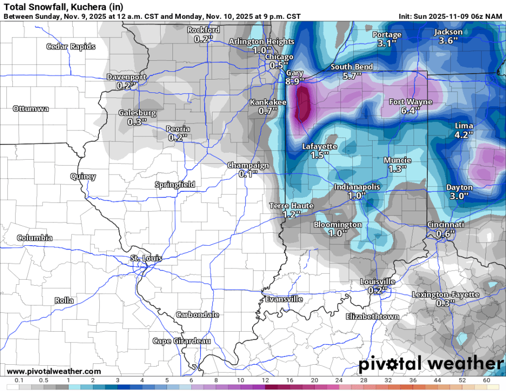
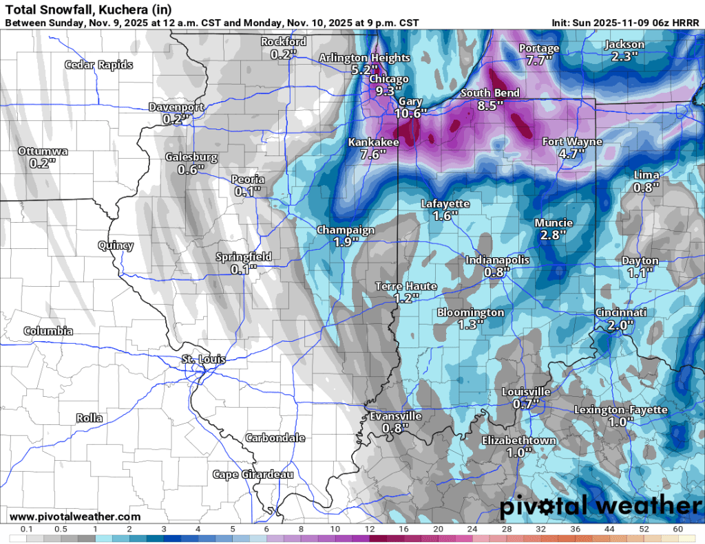
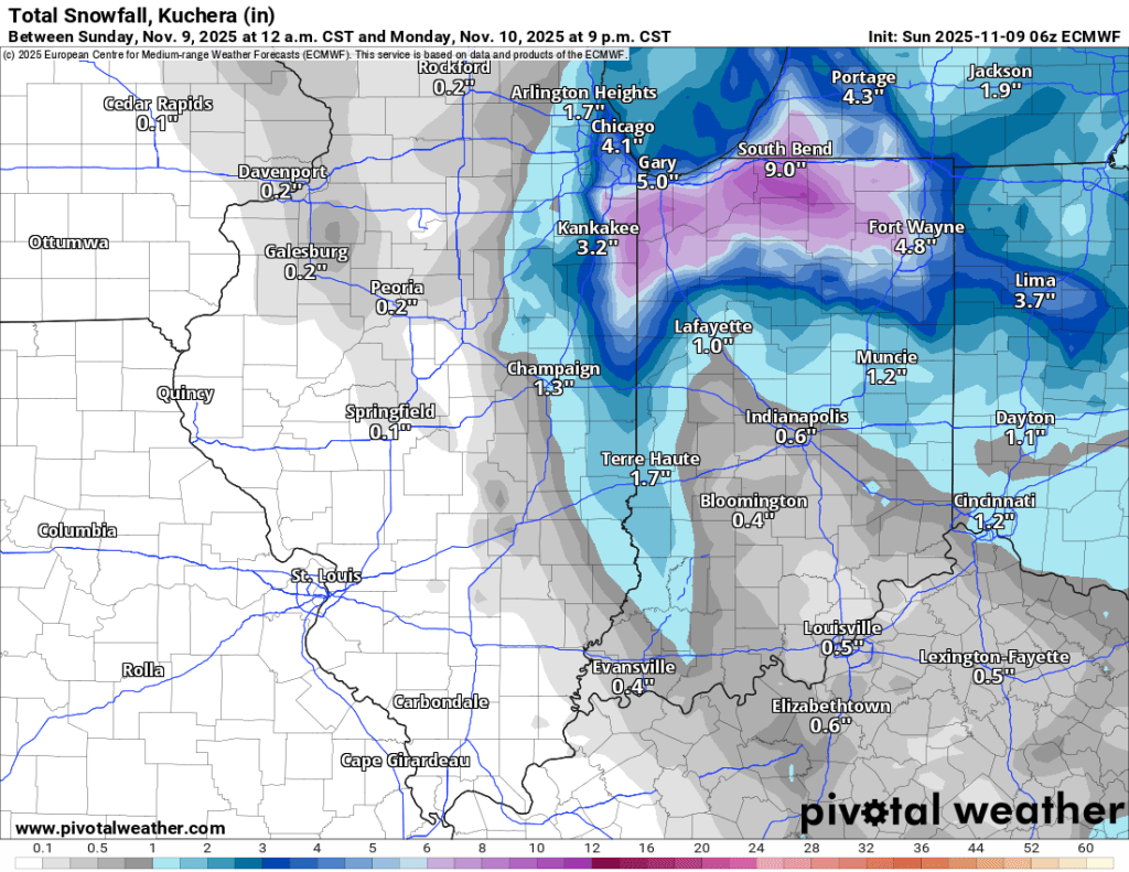
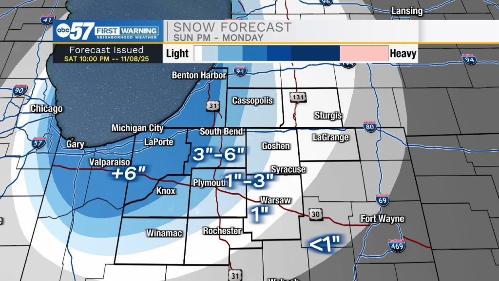
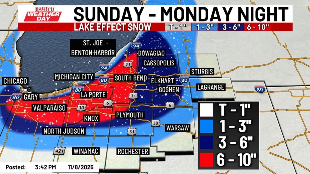
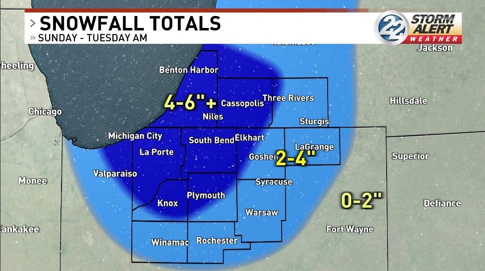
Here are the latest accumulation maps from various outlets and forecast models. You can see that most point toward the snow falling in bulk to our west. However, many of the latest models split the heavy snow on either side of South Bend. I’m showing these to illustrate the extreme variability of Lake Effect and how it leads to low confidence in pinpointing exactly where the snow will fall and exactly who will see how much—this is also why I tend to lean very conservatively with my own forecasts.

Update 2 (Saturday PM, 11/8/25)
All along, the thinking has been that the bulk of the snow would stay west of Goshen, and all of today’s data has continued to support that for the most part. Berrien County in Michigan, along with the western half of St. Joseph County in Indiana, and Laporte and Porter counties, appear to be the bullseye for the lake effect event on Monday. Accumulation of 6”+ is possible in these areas.
Many local media outlets are slightly higher on their totals, but none more so than the 1-2 feet the NWS is advertising for parts of these areas. A lot, and I mean a lot, would have to go just right for that forecast to verify, and I just don’t see it happening. There may be a few very isolated spots between Gary, IN, Berrien Springs, MI, and South Bend, IN that see 8 to possibly even 12”. But I think these will be hard to come by.
I’m sticking to my original 1-3” in Goshen despite many models suggesting more than double that. It is a lake effect event, so anything can happen, but some pretty rare and wild things would have to happen for Goshen to cash in on more than 3” by Monday night, in my opinion.
Conditions will likely be exceedingly variable on Monday for both the morning and afternoon commutes, with moderate to even brief heavy snow in short bursts, followed by patchy sunshine/clear skies. At this range, I don’t see many local travel disruptions. If the snow picks up at the right time in your area, there could be school delays, but I think most of those will also affect areas to our west.
I’ll have more updates tomorrow. If your travels take you west between South Bend and Chicago on Monday, be prepared for significant delays.
Update 1 (Saturday AM, 11/8/25)
The first potential snow of the season is always overhyped and almost always disappointing. There was an early November storm about 6 years ago that gave us roughly 8” in one night, but outside of that, most of these first snow systems are not only overhyped, they leave most disappointed and doubting forecasts the rest of the winter. I do my best to avoid that.
Bottom line, right now I think Goshen gets 1-3” by Monday night. It could come down hard at times, briefly reducing visibility Sunday night and early Monday, but this is the most likely outcome I see at this time. It will be the coldest it’s been yet this year, with temps on Monday stuck in the 20s. And the wind will be blowing and driving windchills into the 10s or even briefly into the single digits. Suffice it to say, regardless of snow totals, Monday will be a 100% winter day. If you live or will be traveling west of Mishawaka towards Chicago on Sunday evening and through Monday, you can expect pockets significant travel disruption due to heavy snow and reduced visibility.
Now, some unique qualities of the approaching system are frankly very similar to the aforementioned November 2019 snowstorm. But a lot would have to go just right, and the “bullseye” would have to shift further east to include us. You can read on for more details and for a first look at a snowfall map.
Model data continues to indicate rain and snow showers from late Saturday night through Sunday evening, with little to no accumulation expected. Sunday night, winds shift and usher in colder air over Lake Michigan. These winds will put us well below freezing, so any precipitation we see will be snow. They are also expected to fire up the lake effect snow machine.
The exact direction of the wind, both several hundred miles up Lake Michigan and several thousand feet above it, will determine how intense the snow is and where it goes.
Models have generally focused the bulk of the snow on St. Joe and LaPorte counties in Indiana, and Berrien and Cass counties in Michigan. However, Elkhart, Lake, and Porter counties in Indiana have also been favored in several model runs. To put it simply, confidence has increased in the likelihood of lake effect snow occurring. However, while nailing it down to a handful of counties is pretty impressive, you don’t need a model to tell you that if you’ve lived here more than a winter or two.
Lake-effect snow bands are notoriously difficult to predict. They are almost always about 10-20 miles wide when most intense, meaning you could be a mile or two on either side of the band and see sunshine, while those under it see whiteout conditions with snowfall rates easily over 1”/hour. This kind of precision is something the models are, and kind of always have, struggling with.
There hasn’t been much consistency out of anything but the blended model. Placement and amounts have varied widely, but the blended model (as expected) has remained reasonably steady. You can see for yourself below.
Using this model, you can see why the counties in the pink and purple are already under a Winter Storm Watch for the potential of 6” or more of snow.
Yes, the ground is still relatively warm, but not as warm as you might think on the surface. Additionally, another factor contributing to the lake effect snow on Sunday night into Monday is the potential development of a mesolow early Monday—this would enhance snowfall rates enough to overcome surface melting and accumulate even earlier.
To drastically oversimplify it, a mesolow is akin to an incredibly small snow hurricane or derecho, with much less intense winds, but precipitation rates at their worst that can rival those of a tropical storm. These mesolows are what produce the crazy high snow totals we sometimes get in northern Indiana. They can easily drop double-digit snow accumulations over a relatively small area.
Mesolows are nearly impossible to predict. Identifying conditions in a forecast that would support the development of a mesolow is relatively easy; however, predicting whether it will actually develop and then where and how it continues to evolve is essentially impossible with current technology.
A mesolow would make a big difference in snow totals for whoever is caught underneath it. Personally, I think without it, the heaviest snow totals will be 3-6”. If a mesolow does form, it could double those amounts, but most likely for a very small area.
I will continue to update this blog as more model runs come in today and even early tomorrow, but again, I think Goshen probably sees 1-3” when all is said and done. It could come down pretty hard at times, and temps on Monday will be in the 20s, so we are jumping right into full-fledged winter for a day or two, which we really haven’t seen yet.
Original Post (Thursday PM, 11/6/25)
Our weekend weather maker(s) are close enough now that we can start to draw some conclusions. There will be roughly three phases to our weekend storm. Rain will eventually change to snow, but when that changeover takes place and where it occurs will make all the difference in seeing cold and wet streets versus a few inches of accumulation. This won’t be the storm of the century or anything close to it. The most likely outcome is an inch or two of slushy accumulation, mainly on elevated and grassy surfaces. However, there is a chance that things line up such that we get more than our typical first snow event of the year. More on that below.
Phase One
The first round is expected to occur overnight tonight into early tomorrow, with some light to moderate rain possible. A few spots could get briefly heavy rain and even a rumble of thunder, but most will likely end up with 0.10-0.25″ of rain by the middle of Friday morning. We’ll still be on the warm side of things at that point and conditions are expected to improve Friday afternoon and evening with temps likely reaching the 60s.
Phase Two
The next phase of the storm arrives on Saturday night, and this is when things could become interesting. Precipitation could be heavy at times, and temperatures are expected to fall below freezing at some point. If the heaviest precipitation aligns with temperatures dropping close to and below freezing, we could see a quick accumulation of snow that falls hard and fast enough to overcome the warm ground temperatures and result in some slushy accumulation of wet snow. Even if this scenario plays out, this looks like a very minor 1-3″ event. If things do not align perfectly, we would see a cold rain that could be heavy at times before mixing with snow Sunday morning and tapering off.
Phase Three
As the system moves east, the winds are expected to shift to the north or northwest. There should be ample cold air at this point for any precipitation to be snow. The lake temperature is still very mild, so the north-northwest breeze over it should fire up the lake effect snow machine. Most guidance indicates that the lake effect snow will be just to our west–as is often the case. We will need to keep an eye on trends, though, because this could actually be a decent setup for an early, low-end, lake effect snow event somewhere in northern Indiana and southwest lower Michigan.
I’ll hold off on posting any maps until we get closer to Saturday night, but I will note that models have become slightly more bullish on snow lately. However, this falls right into the pattern we saw each of the last two winters, when storms would appear very impressive until about 36 hours out, after which models would begin to back off on snowfall totals. I’ll have more brief updates on Facebook and another post on Saturday PM.
-pw

Leave a comment