We had our first significant November snow in 5 years earlier this week. Most in Goshen ended up with 3-5”—in line with our rather conservative forecast. Most of this fell on grassy and elevated surfaces, and the system snow that fell first was compacted by melting and additional snow, so it appeared to be less.
Lake effect snow will always be tricky, but the winds that drive it rarely directly impact Goshen. So if you see forecasts regarding heavy lake effect snow here, take them with a grain of salt. Most of the time, the heaviest snow from Lake Michigan either falls between roughly Gary, IN, and Mishawaka, IN, thanks to north northwest winds, or from Edwardsburg, MI, up through Berrien Springs and along much of the west coast of Michigan, extending as far as Kalamazoo, MI, thanks to westerly winds.
Storm systems spin counterclockwise, so as they approach from the west, we often see southerly winds ahead of the storm. Then, as it passes, the winds shift to the east. Once the storm begins to move away, winds quickly shift out of the north or west, depending on the placement of the low and the direction it is traveling. This is valid year-round, but is more impactful and noticeable in the winter thanks to the snow and cold that the changing wind directions bring. Click the link in the description for more graphics and an expanded explanation from the National Weather Service.

The Week Ahead
Temperatures
Why all the talk about fronts and winds? There are strong signals indicating a potential pattern shift at the beginning of December. However, before we get cold again, we will almost certainly see a period of normal to above temperatures over the second half of November. That’s not to say it won’t be cold in the next two weeks, or that we can’t see snow. In fact, more flakes could mix in overnight this Monday into Tuesday.
Unseasonably warm temperatures today won’t last. The high temperature is expected to break 60°F today. The normal high today is just shy of 50°F. Temperatures for the first half of the coming week are expected to be in the 40s, but are expected to climb into the 50s again later next week.
Precipitation
There are chances for mainly light precipitation off and on much of the coming week. Precipitation totals for the next week could exceed 1.00”.

Beyond
This is where things start to look interesting. Over the next two weeks, you may start hearing the term “polar vortex” again. This will be thanks to a potential sudden stratospheric warming (SSW) event forecasted to unfold at the end of November. This kind of thing happens all winter, but generally stays well to our north in Canada until January or so, when these waves of cold, dry, continental polar air arrive in the U.S.
A lobe of the polar vortex becoming dislodged and reaching us in late November or early December is not unheard of, but it is rare. As a result, my conservative forecasting proclivities lead to some doubt. I doubt a full-fledged artic blast, which we tend to see later in winter (subzero temperatures, windchills of -15°F or lower), is likely, but we could see air cold enough to result in snow. Additionally, the lake will remain warm and may produce more lake-effect snow nearby, depending on the wind direction.
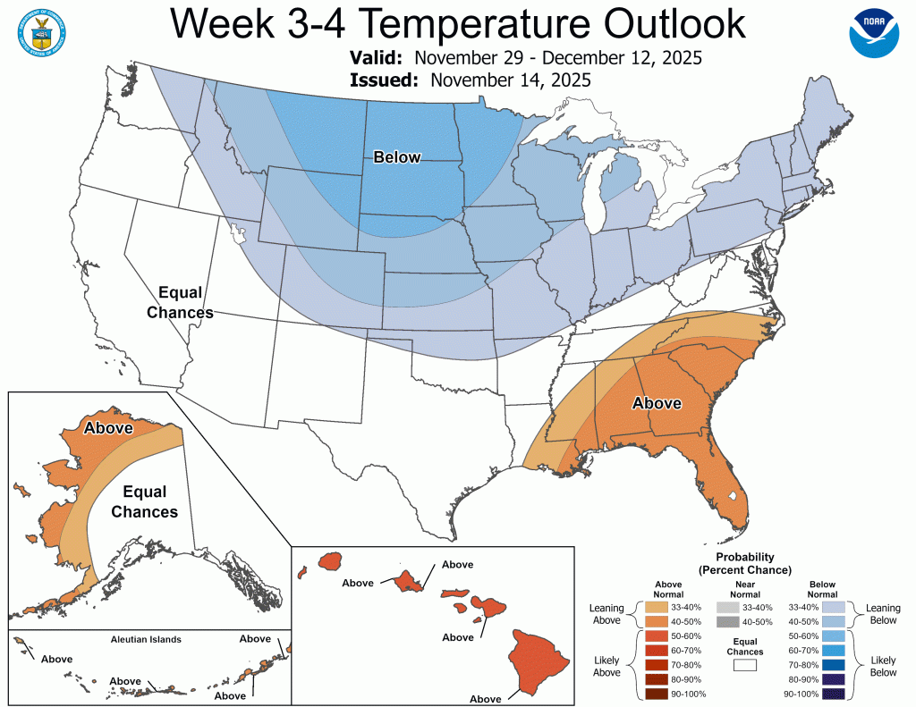
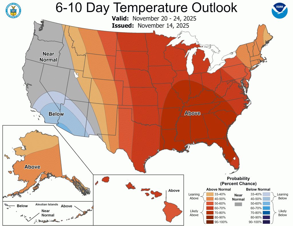
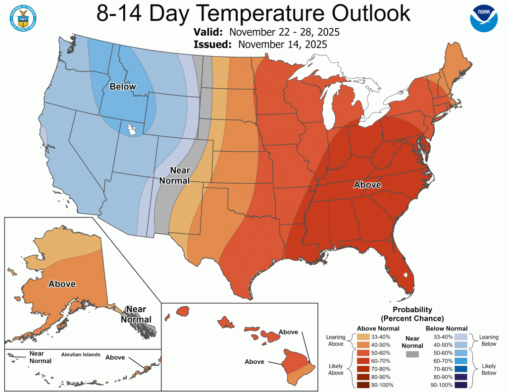
You can see the temperature swings in the CPC Outlooks below.

If you click the link to visit the CPC website above, you’ll see something I don’t recall ever seeing before. There is a link to a key message regarding a wholesale pattern change. You can see that message here.
I’ve started working on my winter forecast here and there, and it should be ready by Thanksgiving Day as expected. Maybe (hopefully) by then we will be talking about an impending snowstorm!
Enjoy the warm weather this morning; this looks like the last time we will be in the mid-60s for a long time—especially this early in the day.
-pw

Leave a comment