
Summary: December1 2025 through February 2026
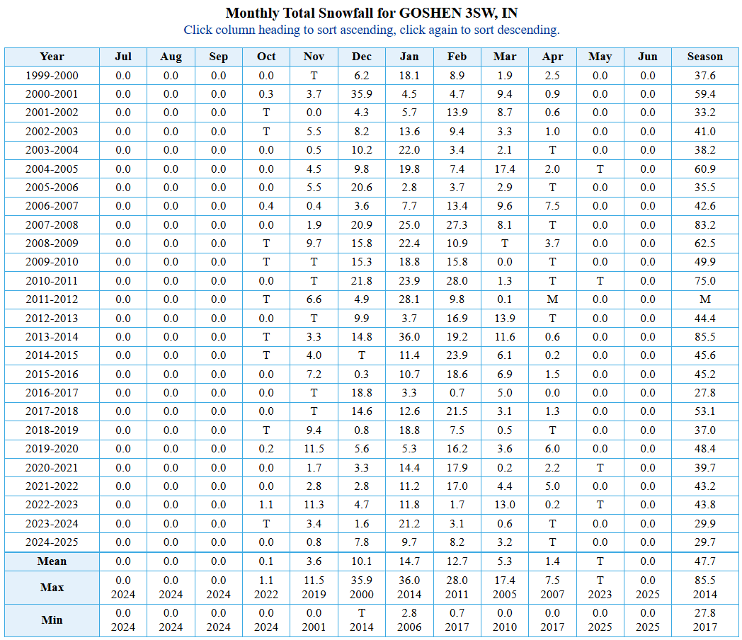
- Total Snowfall: 50” (+2″ , 2000-2025 normal)
- Average Temperature: 25.5F (-2.5F, 1991-2020 normal)
- Overview: High confidence in front-loaded cold with chances for snow, but less confidence that the significance of snow accumulation matches the significance of the cold expected–especially early this winter. The bulk of the snow will likely fall in December and early January. There aren’t many historical comparisons to the way things have unfolded thus far late this fall in terms of the polar vortex, but those that do exist point to a higher chance of more cold and less snow this winter. There are outliers, like the winter of 2013/2014, with strong connections to the upcoming winter, though, so I’m hedging my bet a little.
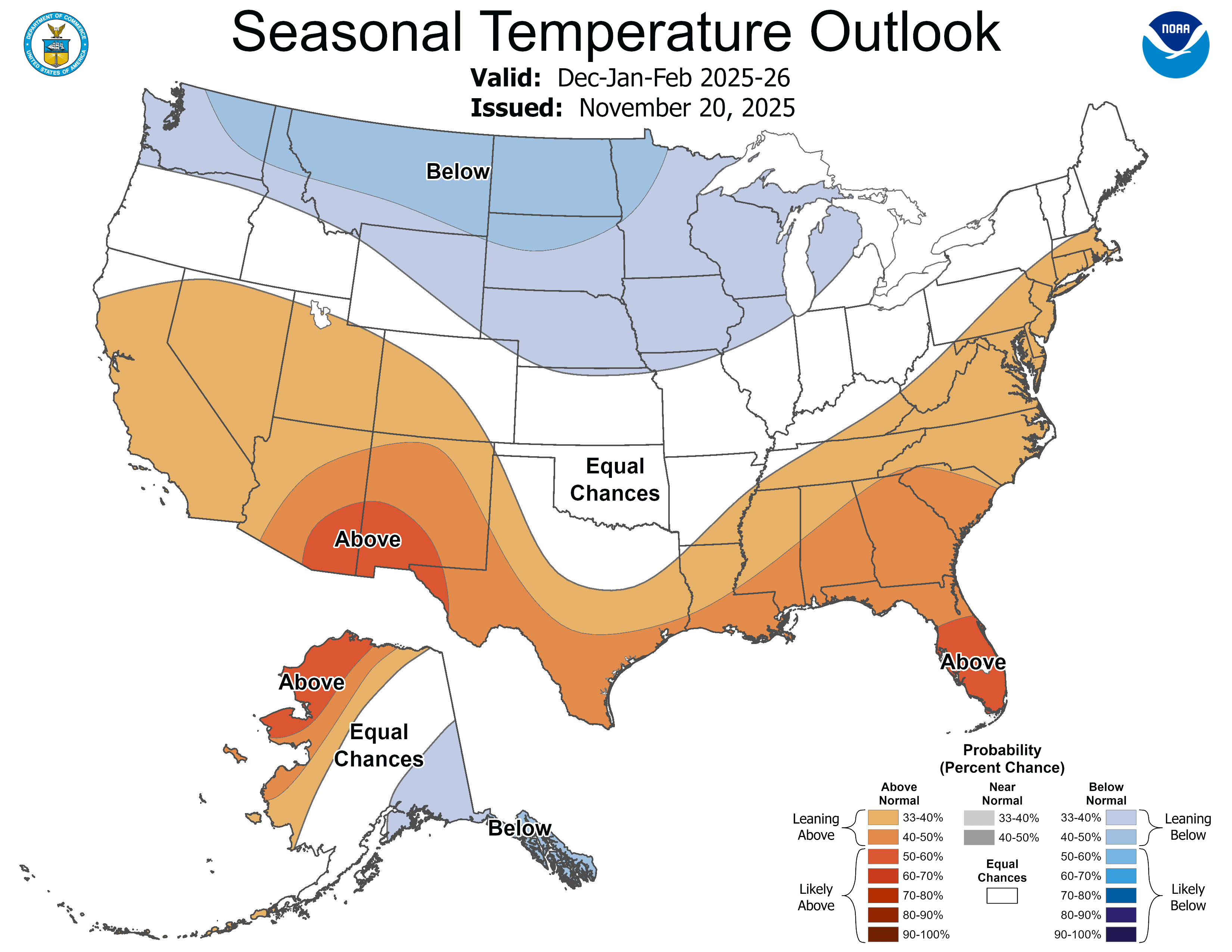
Temperatures – Below Normal
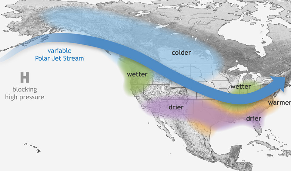
- Cold air is very likely early this winter thanks to a historic breakdown of the polar vortex. The polar vortex is essentially a river of air that acts as a barrier, separating the true polar air from the rest of the northern hemisphere. But occasionally, the river slows and breaks down, allowing the cold air to spill out.
- I’m oversimplifying this, but the general idea is clear: if the polar vortex breaks down, it typically means cold air will soon be in Canada and the United States.
- These breakdowns happen just about every winter, but only 3 times in the last 70 years has one happened before December, and it is happening again right now.
- This early breakdown is a big reason why I believe in a memorably cold December ahead. While we will certainly see a few above-normal temperatures, especially in the second half, the winter ahead looks very cold compared to recent years.
- The latest climate norms (1991-2020) have the average high in Goshen in December at 36.5°F with a low of 23.7°F. I expect to see several nights in the single digits, with highs generally struggling to get above freezing for much of December.
- The rest of the winter may not be quite as cold, but even if we stay close to normal overall, the cold in December should keep our average for the entire winter a few degrees below normal.
- Other factors supporting a colder-than-normal winter include a weak La Niña, analog connections to other cold winters (including 2013-2014), and early-season snow and cold in Siberia, which has helped break down the polar vortex early, too.
Precipitation – Above Normal
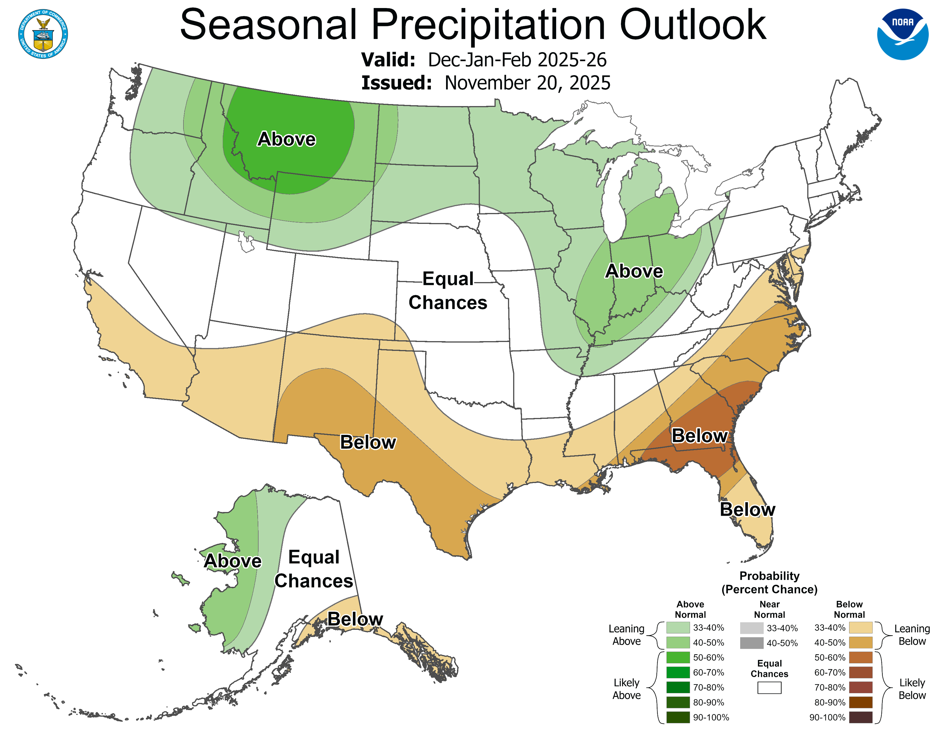
- We are expecting a moderate to potentially heavy snow event in the next few days. Unfortunately, this won’t count toward the official meteorological winter season, but it will certainly count in our memories. My 50″ projection does include any snow we get through November. We’ve already had close to 10″ this November, and we could see that number double over the last few days of the month. Even if December (10.1″), January (14.7″), and February (12.7″) are close to normal (37.5″) this winter, that would put us well over 50″.
- Even in a weak La Nina set up like we have now, there is often more moisture available. We have seen this a few times in recent years, but temperatures in the past few years have favored more rain than snow. This year could be different with the (extremely) cold air expected, especially early this winter.
- I suspect we will see more snow early in the season and I think our odds for a snowy holiday season are higher than they have been for many years.
- The early cold air will provide opportunities for snow, but if it gets cold enough, it could limit moisture availability at times.
- We haven’t had a “normal” (47.8″) or above amount of snow since the winter of 2019-2020 (48.4″). The last two winters have ended with about 30″ each, meaning we are nearly 40″ below normal over the last two winters combined. Even a normal amount of snow this winter would feel like a lot, because that would mean 20″ more than last year.
- I think the odds of us seeing normal, or even a few inches above normal, are pretty good this winter. Given the early-season cold, we could rack up the snow so long as the moisture remains available.
- My concern is that along with the cold air comes a lack of moisture. This would limit lake-effect snow, and we would rely on systems to draw moisture from the Gulf and dump snow. However, even a weak La Nina would support more moisture, and the polar vortex, thanks to early-season Siberian snow, has the jet stream in a favorable position to deliver storm systems our way this winter.
Breakdown
- Analog forecasts have tied the upcoming winter to some heavy-hitting winters of the last, most notably 2013/2014, when we had one of the harshest winter periods in recent and distant memory. Late December 2013 and early January 2014 were marked by heavy snow and brutal cold that extended many local schools’ winter breaks by another week. All signs point toward our best chances since then for seeing that kind of cold this winter, albeit a little earlier in the season. The jury is still out on the snow, but with all that cold, the potential will be there.
- Another key teleconnection to forecasting the winter in the Great Lakes is the extent of snow cover between the source of the cold air and here. The key area is Siberia, and the snow came early and often. Considerable snowfall in these areas makes it easier for cold air to make it to us. It can also help lock in the cold.
- The last significant teleconnection has to do with the polar vortex. The polar vortex never really leaves the polar region, but, it can be come disrupted and when that happens it opens the door for true arctic air to invade. Think of the polar vortex like the gate around the dinosaurs at Jurassic Park, but instead of dinosaurs, its continental polar air. When the polar vortex breaks down, it’s like when the power goes out and the T-Rex tears the fence down. But again, it’s continental polar air (cold and dry) instead of dinosaurs. And just like dinosaurs, once they’re loose, it takes a while to get them back. If the polar vortex breaks down in late November, it bodes well for lasting cold air and significantly boosts the chances for snow.
- Lake Michigan’s waters are in the 40s as of this writing, which will create opportunities for lake-effect snow. The early-season cold could result in earlier ice cover on the lake, shutting off the lake-effect snow machine and putting a damper on my winter snow forecast. However, I am hopeful that the favorable jet stream will send systems our way all winter. These systems almost always result in more snow for us in Goshen than most lake-effect snow events.
There you have it! The 2025/2026 Winter Outlook. I’m dreaming of a white Christmas and a snowy, cold winter, and if you are too, there is a mountain of data supporting it this year. Be sure to check out our online store during the holidays for surprise discounts, including Black Friday and storm-related sales!
- Snowfall totals in this outlook include November, Temperature outlooks are for December through February ↩︎

Leave a comment