
Make a one-time donation
Make a monthly donation
Make a yearly donation
Choose an amount
Or enter a custom amount
Thank you so much for considering!
Your contribution is appreciated.
Your contribution is appreciated.
DonateDonate monthlyDonate yearly-
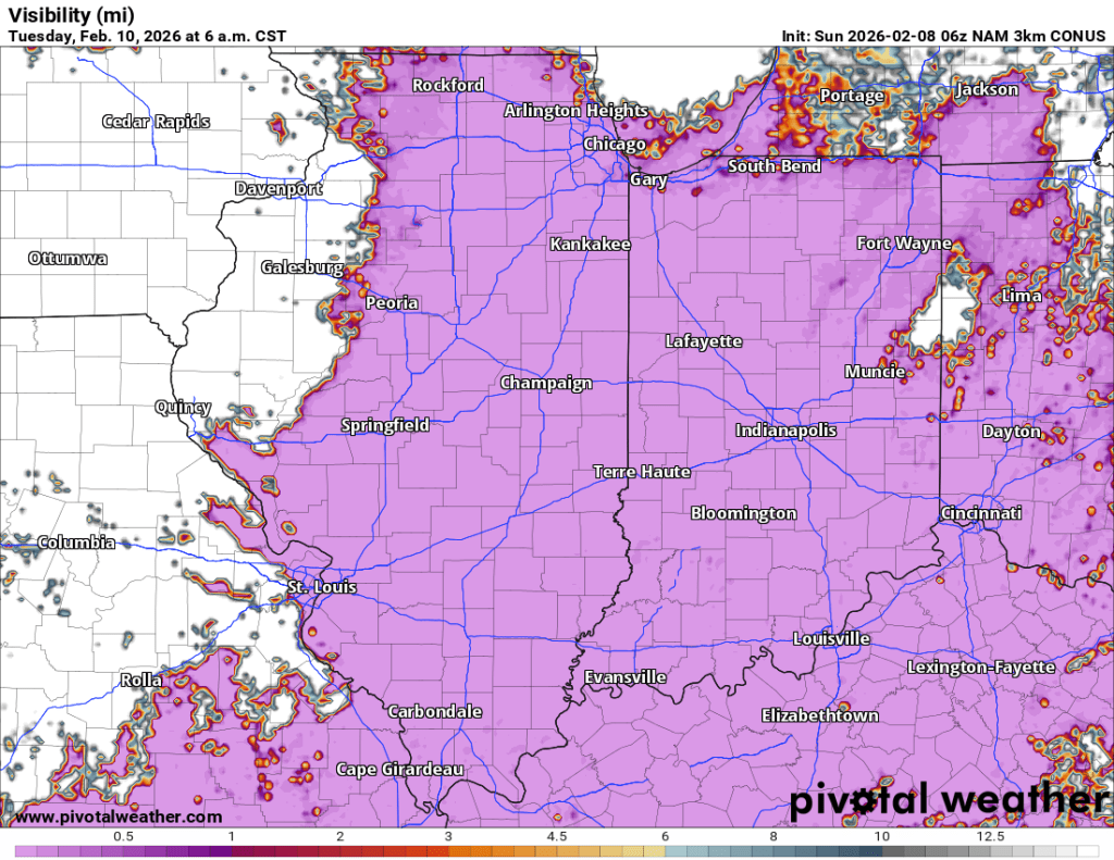
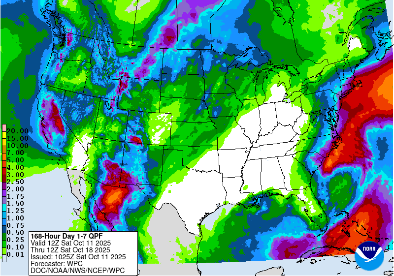
Quiet Week Ahead
After an eventful stretch of wintry weather, we will finally catch a break, as essentially zero meaningful precipitation is expected, and the only potential weather-related impact in the coming week is fog. Tuesday AM is the one to watch for… Continue reading
-
Where is Winter?
While certain aspects of northern Indiana winter have been here all season (that’s you, permacloud and wind), one thing has been missing for weeks now: snow. Looking back at the data from 2025, not only are we falling behind on… Continue reading
-
Tranquil, for the most part
Once our clipper system moves through today, things look pretty tame until perhaps the middle of next week when our next potential system may arrive. Temperatures Overall, temperatures over the next week or so look normal to slightly below. Toward… Continue reading
-
Autumn Doldrums
We are officially in transition mode, also known as “fall” in northern Indiana. The last three (four?) months have been dominated by above normal temperatures and long stretches of sunny days. That’s probably why the last few dreary days have… Continue reading
-
Fall Pattern (finally) Settling In
Overall, the weather pattern for the next 7+ days looks cooler than it has been, but very pleasant. Unfortunately, the exceedingly dry pattern also looks to continue. We get briefly warmer later this weekend and early next week with highs… Continue reading
-
Changes Brewing
Historically warm in the short range, but much closer to normal (and much cooler) by next week. Continue reading
-
Another Nice Week Ahead
We’ve been pretty spoiled lately with generally spectacular weather, albeit a little cool lately. The nice weather is expected to continue, but the chilly/cool temperatures lately will moderate significantly as we get to midweek. A return to near 80°F is… Continue reading
-
Gorgeous Long Weekend, Chilly Week
Gorgeous weather is expected through at least Monday, and most likely Tuesday as well. Wednesday, especially late, will be our transition day. Until then, you can expect lots of sunshine, cool and crisp mornings followed by warm afternoons and early… Continue reading

-
(Another) Heat Wave Coming
Updated 8/9 I have added the latest temperature outlooks and they have gotten even warmer over the next two weeks. Another run at 100°F heat index values is possible next week. We could meet or exceed Heat Advisory criteria after… Continue reading

-
Summer Doldrums
July 2025 thus far Goshen, along with much of the Midwest and Great Lakes, has been mired in a prolonged stretch of above normal temperatures with normal to slightly below normal precipitation and varying levels of humidity. None of this… Continue reading
