Make a one-time donation
Make a monthly donation
Make a yearly donation
Choose an amount
Or enter a custom amount
Thank you so much for considering!
Your contribution is appreciated.
Your contribution is appreciated.
DonateDonate monthlyDonate yearly-
Tranquil, for the most part
Once our clipper system moves through today, things look pretty tame until perhaps the middle of next week when our next potential system may arrive. Temperatures Overall, temperatures over the next week or so look normal to slightly below. Toward… Continue reading
-
Minor Ice Potential Friday
I hope you were able to enjoy the warm air yesterday. My car said it was 54°F yesterday afternoon, but my backyard thermometer peaked at 49.8°F. Either way, it was great! Models have backed off on the truly warm air… Continue reading

-
Fall Pattern (finally) Settling In
Overall, the weather pattern for the next 7+ days looks cooler than it has been, but very pleasant. Unfortunately, the exceedingly dry pattern also looks to continue. We get briefly warmer later this weekend and early next week with highs… Continue reading
-
Changes Brewing
Historically warm in the short range, but much closer to normal (and much cooler) by next week. Continue reading
-
Another Nice Week Ahead
We’ve been pretty spoiled lately with generally spectacular weather, albeit a little cool lately. The nice weather is expected to continue, but the chilly/cool temperatures lately will moderate significantly as we get to midweek. A return to near 80°F is… Continue reading
-
Cool and Dry Spell to Continue
The low clouds have managed to hold on now for two full days longer than expected. That has helped keep temperatures down a bit more than expected, too. For most, this has been a welcome change from the oppressive and… Continue reading
-
(Another) Heat Wave Coming
Updated 8/9 I have added the latest temperature outlooks and they have gotten even warmer over the next two weeks. Another run at 100°F heat index values is possible next week. We could meet or exceed Heat Advisory criteria after… Continue reading

-
Summer Doldrums
July 2025 thus far Goshen, along with much of the Midwest and Great Lakes, has been mired in a prolonged stretch of above normal temperatures with normal to slightly below normal precipitation and varying levels of humidity. None of this… Continue reading
-
Potential Severe Weather Event Thursday
Thursday PM Update The latest update from the Storm Prediction Center (SPC) has expanded the area of enhanced risk further south, putting us in a more favorable zone for severe weather. High-risk areas for tornadoes, severe wind gusts, and severe… Continue reading

-
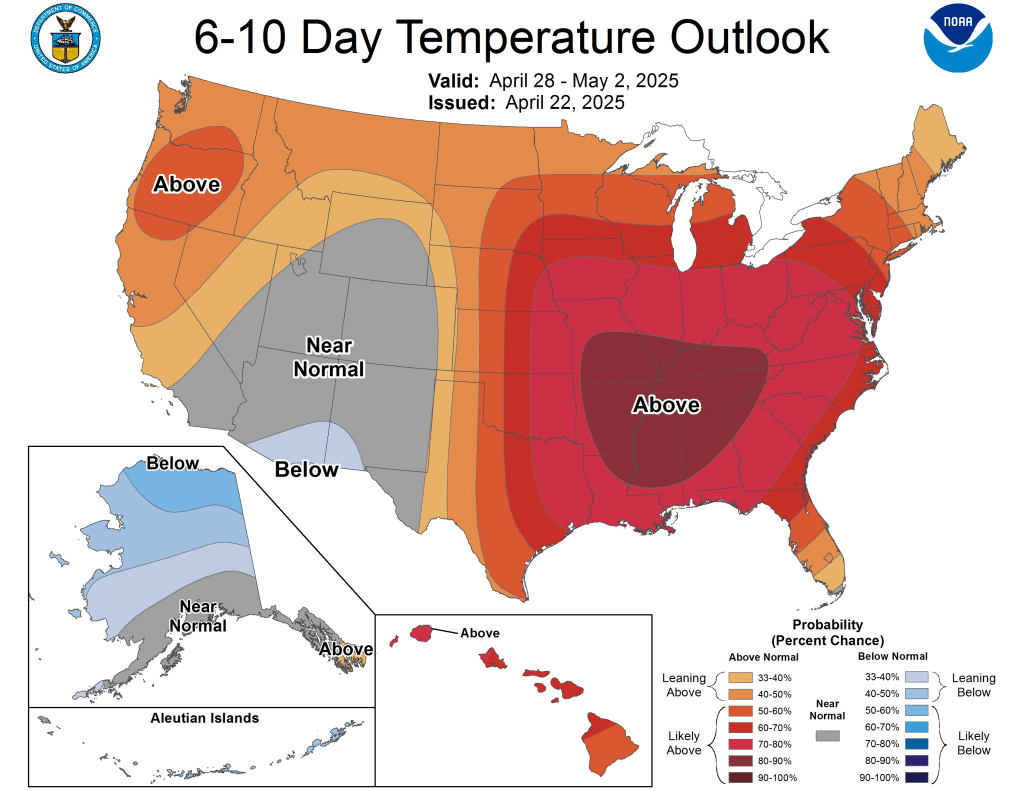
Summer-like pattern ahead
4/23/25 PM Update The SPC did include our area in the next day’s 15% severe weather risk outlook (current day seven) as expected and shown below. Tuesday will be a day to keep an eye on for heavy rain and… Continue reading